Kosigi geodata
Kosigi (Andhra Pradesh) is a populated place; located in India in Asia/Kolkata (GMT+5.5) time zone. With population of 15,455 people, there are 2419 cities with bigger population in this country. Compared to other cities in India, 78.4% of cities are located further ↑North; 60.6% of cities are located further →East and 75% of cities have lower elevation than Kosigi. Note1


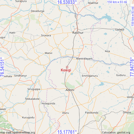
Kosigi GPS coordinates[2]
15° 51' 18.36" North, 77° 14' 40.668" East
| Map corner | latitude | longitude |
|---|---|---|
| Upper-left | 16.53033°, | 76.54151° |
| Center: | 15.8551°, | 77.24463° |
| Lower-right: | 15.17761°, | 77.94776° |
| Map W x H: | 150.4×150.4 km | = 93.5×93.5mi |
| max Lat: | 34.9274° ⇑78.4% North |
| Kosigi: | 15.8551° |
| min Lat: | ⇓21.6% South 8.09008° |
| min Long | Kosigi | max Long |
| 68.82655° | 77.24463° | 96.81° |
| W 39.4%⇐ | ⇒60.6% E |
Elevation
Elevation of Kosigi is 386 m = 1266 ft, and this is 90.4 m = 297 ft above average elevation for this country.
| Max E: |
3681 m = 12077 ft | 25% |
| Kosigi | 386 m 1266 ft | |
| Avg. | 295.6 m = 970 ft | |
Min E: |
1 m = 3 ft | 75% |
See also: India elevation on elevation.city.
Geographical zone
Kosigi is located in North Torrid zone (between Equator and Tropic of Cancer). Distance of this Northern Tropic circle is 843 km =523.8 mi to North.| Distance of | km | miles | from Kosigi |
|---|---|---|---|
| North Pole | 8244.1 | 5122.6 | to North |
| Arctic Circle | 5638.3 | 3503.5 | to North |
| Tropic Cancer | 843 | 523.8 | to North |
| Equator | 1762.9 | 1095.4 | to South |


Nearby cities:
15 places around Kosigi: (largest is in red/bold)
• Bellary
86.4 km =53.7 mi,  203°
203°
• Dhone
84.4 km =52.4 mi,  127°
127°
• Emmiganūr
27.2 km =16.9 mi,  109°
109°
• Gadwāl
72.5 km =45 mi,  54°
54°
• Guntakal Junction
77.1 km =47.9 mi,  170°
170°
• Kampli
85.2 km =52.9 mi,  234°
234°
• Kurnool
84.7 km =52.6 mi,  91°
91°
• Lingsugūr
84.3 km =52.4 mi,  293°
293°
• Mudgal
87.6 km =54.4 mi,  281°
281°
• Mānvi
25.7 km =16 mi,  306°
306°
• Rāichūr
40.7 km =25.3 mi,  16°
16°
• Sindhnūr
53.1 km =33 mi,  259°
259°
• Siruguppa
45.3 km =28.1 mi,  236°
236°
• Tekkalakote
53.1 km =33 mi, 227°
• Ādoni
25.5 km =15.8 mi, 172°
Sources, notices
• [Note1] Compared only with cities in India existing in our database
• [Src1] Map data: © OpenStreetMap contributors (CC-BY-SA)
• [Src2] Other city data from geonames.org with taken over terms of usage.
• [Src3] Geographical zone / Annual Mean Temperature by Robert A. Rohde @ Wikipedia
