Guntakal Junction geodata
Guntakal Junction (Andhra Pradesh) is a populated place; located in India in Asia/Kolkata (GMT+5.5) time zone. With population of 120,964 people, there are 366 cities with bigger population in this country. Compared to other cities in India, 81.4% of cities are located further ↑North; 58.7% of cities are located further →East and 79.9% of cities have lower elevation than Guntakal Junction. Note1


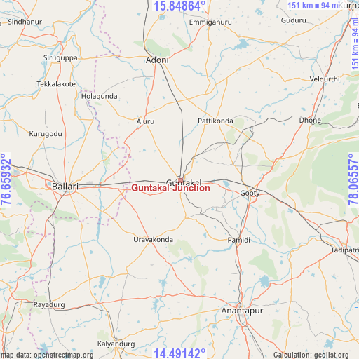
Guntakal Junction GPS coordinates[2]
15° 10' 16.032" North, 77° 21' 44.784" East
| Map corner | latitude | longitude |
|---|---|---|
| Upper-left | 15.84864°, | 76.65932° |
| Center: | 15.17112°, | 77.36244° |
| Lower-right: | 14.49142°, | 78.06557° |
| Map W x H: | 150.9×150.9 km | = 93.8×93.8mi |
| max Lat: | 34.9274° ⇑81.4% North |
| Guntakal Junction: | 15.17112° |
| min Lat: | ⇓18.6% South 8.09008° |
| min Long | Guntakal Juncti | max Long |
| 68.82655° | 77.36244° | 96.81° |
| W 41.3%⇐ | ⇒58.7% E |
Elevation
Elevation of Guntakal Junction is 457 m = 1499 ft, and this is 161.4 m = 530 ft above average elevation for this country.
| Max E: |
3681 m = 12077 ft | 20.1% |
| Guntakal Junction | 457 m 1499 ft | |
| Avg. | 295.6 m = 970 ft | |
Min E: |
1 m = 3 ft | 79.9% |
See also: Guntakal Junction elevation on elevation.city.
Geographical zone
Guntakal Junction is located in North Torrid zone (between Equator and Tropic of Cancer). Distance of this Northern Tropic circle is 919 km =571 mi to North.| Distance of | km | miles | from Guntakal Junction |
|---|---|---|---|
| North Pole | 8320.2 | 5169.9 | to North |
| Arctic Circle | 5714.3 | 3550.7 | to North |
| Tropic Cancer | 919 | 571 | to North |
| Equator | 1686.9 | 1048.2 | to South |


Nearby cities:
15 places around Guntakal Junction: (largest is in red/bold)
• Anantapur
60.9 km =37.8 mi,  154°
154°
• Bellary
47.2 km =29.3 mi,  266°
266°
• Dhone
60 km =37.3 mi,  65°
65°
• Emmiganūr
68.1 km =42.3 mi,  10°
10°
• Kalyandurg
74.9 km =46.5 mi,  201°
201°
• Kampli
85.8 km =53.3 mi,  287°
287°
• Kosigi
77.1 km =47.9 mi,  350°
350°
• Rāmāpuram
55.7 km =34.6 mi,  76°
76°
• Rāyadrug
75.8 km =47.1 mi,  226°
226°
• Sandūr
88 km =54.7 mi,  263°
263°
• Siruguppa
71.7 km =44.6 mi,  315°
315°
• Tekkalakote
65.9 km =40.9 mi,  307°
307°
• Tādpatri
75.5 km =46.9 mi,  112°
112°
• Uravakonda
27.8 km =17.3 mi, 204°
• Ādoni
51.6 km =32.1 mi, 349°
Sources, notices
• [Note1] Compared only with cities in India existing in our database
• [Src1] Map data: © OpenStreetMap contributors (CC-BY-SA)
• [Src2] Other city data from geonames.org with taken over terms of usage.
• [Src3] Geographical zone / Annual Mean Temperature by Robert A. Rohde @ Wikipedia
