Gangāwati geodata
Gangāwati (Karnataka) is a populated place; located in India in Asia/Kolkata (GMT+5.5) time zone. With population of 106,250 people, there are 413 cities with bigger population in this country. Compared to other cities in India, 80% of cities are located further ↑North; 68.1% of cities are located further →East and 77.1% of cities have lower elevation than Gangāwati. Note1


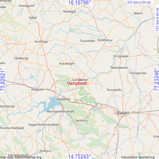
Gangāwati GPS coordinates[2]
15° 25' 52.68" North, 76° 31' 45.588" East
| Map corner | latitude | longitude |
|---|---|---|
| Upper-left | 16.10796°, | 75.82621° |
| Center: | 15.4313°, | 76.52933° |
| Lower-right: | 14.75243°, | 77.23246° |
| Map W x H: | 150.7×150.7 km | = 93.6×93.6mi |
| max Lat: | 34.9274° ⇑80% North |
| Gangāwati: | 15.4313° |
| min Lat: | ⇓20% South 8.09008° |
| min Long | Gangāwati | max Long |
| 68.82655° | 76.52933° | 96.81° |
| W 31.9%⇐ | ⇒68.1% E |
Elevation
Elevation of Gangāwati is 415 m = 1362 ft, and this is 119.4 m = 392 ft above average elevation for this country.
| Max E: |
3681 m = 12077 ft | 22.9% |
| Gangāwati | 415 m 1362 ft | |
| Avg. | 295.6 m = 970 ft | |
Min E: |
1 m = 3 ft | 77.1% |
See also: Gangāwati elevation on elevation.city.
Geographical zone
Gangāwati is located in North Torrid zone (between Equator and Tropic of Cancer). Distance of this Northern Tropic circle is 890.1 km =553.1 mi to North.| Distance of | km | miles | from Gangāwati |
|---|---|---|---|
| North Pole | 8291.3 | 5152 | to North |
| Arctic Circle | 5685.4 | 3532.7 | to North |
| Tropic Cancer | 890.1 | 553.1 | to North |
| Equator | 1715.8 | 1066.1 | to South |


Nearby cities:
15 places around Gangāwati: (largest is in red/bold)
• Bellary
53.2 km =33.1 mi,  127°
127°
• Hampi
13 km =8.1 mi,  214°
214°
• Hospet
23.6 km =14.7 mi,  220°
220°
• Kampli
8.1 km =5 mi,  110°
110°
• Kavalūr
64.8 km =40.3 mi,  255°
255°
• Koppal
41.3 km =25.7 mi, 256°
• Kushtagi
51.2 km =31.8 mi,  314°
314°
• Kūdligi
60.5 km =37.6 mi,  194°
194°
• Mudgal
65.2 km =40.5 mi,  351°
351°
• Munirābād
24.6 km =15.3 mi,  236°
236°
• Sandūr
38.4 km =23.9 mi,  177°
177°
• Sindhnūr
44.8 km =27.8 mi,  32°
32°
• Siruguppa
44.7 km =27.8 mi,  60°
60°
• Tekkalakote
39 km =24.2 mi,  72°
72°
• Yelbarga
59.1 km =36.7 mi,  290°
290°
Sources, notices
• [Note1] Compared only with cities in India existing in our database
• [Src1] Map data: © OpenStreetMap contributors (CC-BY-SA)
• [Src2] Other city data from geonames.org with taken over terms of usage.
• [Src3] Geographical zone / Annual Mean Temperature by Robert A. Rohde @ Wikipedia
