Tājpur geodata
Tājpur (Uttar Pradesh) is a populated place; located in India in Asia/Kolkata (GMT+5.5) time zone. With population of 17,529 people, there are 2235 cities with bigger population in this country. Compared to other cities in India, 89.6% of cities are located further ↓South; 54.1% of cities are located further ←West and 55.1% of cities have lower elevation than Tājpur. Note1


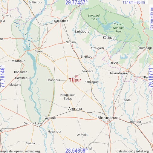
Tājpur GPS coordinates[2]
29° 9' 44.712" North, 78° 29' 4.488" East
| Map corner | latitude | longitude |
|---|---|---|
| Upper-left | 29.77457°, | 77.78146° |
| Center: | 29.16242°, | 78.48458° |
| Lower-right: | 28.54659°, | 79.18771° |
| Map W x H: | 136.5×136.5 km | = 84.8×84.8mi |
| max Lat: | 34.9274° ⇑10.4% North |
| Tājpur: | 29.16242° |
| min Lat: | ⇓89.6% South 8.09008° |
| min Long | Tājpur | max Long |
| 68.82655° | 78.48458° | 96.81° |
| W 54.1%⇐ | ⇒45.9% E |
Elevation
Elevation of Tājpur is 227 m = 745 ft, and this is 68.6 m = 225 ft below average elevation for this country.
| Max E: |
3681 m = 12077 ft | 44.9% |
| Avg. | 295.6 m = 970 ft | |
| Tājpur | 227 m = 745 ft | |
Min E: |
1 m = 3 ft | 55.1% |
See also: India elevation on elevation.city.
Geographical zone
Tājpur is located in North temperate zone (between Tropic of Cancer and the Arctic Circle). Distance of this Northern Tropic circle is 636.6 km =395.6 mi to South.| Distance of | km | miles | from Tājpur |
|---|---|---|---|
| North Pole | 6764.5 | 4203.3 | to North |
| Arctic Circle | 4158.6 | 2584 | to North |
| Tropic Cancer | 636.6 | 395.6 | to South |
| Equator | 3242.6 | 2014.9 | to South |


Nearby cities:
15 places around Tājpur: (largest is in red/bold)
• Afzalgarh
31.6 km =19.6 mi,  35°
35°
• Amroha
28.9 km =18 mi,  182°
182°
• Bachhraon
35.7 km =22.2 mi,  222°
222°
• Chāndpur
20.9 km =13 mi,  261°
261°
• Dhanaura
31.7 km =19.7 mi, 224°
• Dhāmpur
16.5 km =10.3 mi,  8°
8°
• Haldaur
24 km =14.9 mi,  306°
306°
• Jhālu
31.7 km =19.7 mi, 307°
• Kānth
18.2 km =11.3 mi,  129°
129°
• Nagīna
31.7 km =19.7 mi,  351°
351°
• Nihtaur
20.3 km =12.6 mi,  332°
332°
• Nūrpur
7.5 km =4.7 mi, 259°
• Sahaspur
14.2 km =8.8 mi,  108°
108°
• Seohāra
11.3 km =7 mi,  62°
62°
• Sherkot
20.3 km =12.6 mi,  25°
25°
Sources, notices
• [Note1] Compared only with cities in India existing in our database
• [Src1] Map data: © OpenStreetMap contributors (CC-BY-SA)
• [Src2] Other city data from geonames.org with taken over terms of usage.
• [Src3] Geographical zone / Annual Mean Temperature by Robert A. Rohde @ Wikipedia
