Dhanaura geodata
Dhanaura (Uttar Pradesh) is a populated place; located in India in Asia/Kolkata (GMT+5.5) time zone. With population of 28,285 people, there are 1525 cities with bigger population in this country. Compared to other cities in India, 88.9% of cities are located further ↓South; 51.8% of cities are located further ←West and 54.5% of cities have lower elevation than Dhanaura. Note1


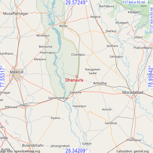
Dhanaura GPS coordinates[2]
28° 57' 32.832" North, 78° 15' 22.644" East
| Map corner | latitude | longitude |
|---|---|---|
| Upper-left | 29.57249°, | 77.55317° |
| Center: | 28.95912°, | 78.25629° |
| Lower-right: | 28.34209°, | 78.95942° |
| Map W x H: | 136.8×136.8 km | = 85×85mi |
| max Lat: | 34.9274° ⇑11.1% North |
| Dhanaura: | 28.95912° |
| min Lat: | ⇓88.9% South 8.09008° |
| min Long | Dhanaura | max Long |
| 68.82655° | 78.25629° | 96.81° |
| W 51.8%⇐ | ⇒48.2% E |
Elevation
Elevation of Dhanaura is 224 m = 735 ft, and this is 71.6 m = 235 ft below average elevation for this country.
| Max E: |
3681 m = 12077 ft | 45.5% |
| Avg. | 295.6 m = 970 ft | |
| Dhanaura | 224 m = 735 ft | |
Min E: |
1 m = 3 ft | 54.5% |
See also: India elevation on elevation.city.
Geographical zone
Dhanaura is located in North temperate zone (between Tropic of Cancer and the Arctic Circle). Distance of this Northern Tropic circle is 614 km =381.5 mi to South.| Distance of | km | miles | from Dhanaura |
|---|---|---|---|
| North Pole | 6787.1 | 4217.3 | to North |
| Arctic Circle | 4181.2 | 2598.1 | to North |
| Tropic Cancer | 614 | 381.5 | to South |
| Equator | 3220 | 2000.8 | to South |


Nearby cities:
15 places around Dhanaura: (largest is in red/bold)
• Amroha
21.7 km =13.5 mi,  106°
106°
• Bachhraon
4.2 km =2.6 mi,  210°
210°
• Bahsūma
38.5 km =23.9 mi,  314°
314°
• Chāndpur
19.6 km =12.2 mi,  4°
4°
• Gajraula
12.7 km =7.9 mi,  187°
187°
• Garhmuktesar
24.3 km =15.1 mi,  218°
218°
• Haldaur
36.9 km =22.9 mi, 4°
• Hasanpur
26.5 km =16.5 mi,  174°
174°
• Hastināpur
32.9 km =20.4 mi, 312°
• Kithor
32.6 km =20.3 mi,  251°
251°
• Kānth
38 km =23.6 mi,  72°
72°
• Mawāna
36.2 km =22.5 mi,  296°
296°
• Nūrpur
25.8 km =16 mi,  34°
34°
• Parīchhatgarh
31.4 km =19.5 mi,  273°
273°
• Tājpur
31.7 km =19.7 mi,  44°
44°
Sources, notices
• [Note1] Compared only with cities in India existing in our database
• [Src1] Map data: © OpenStreetMap contributors (CC-BY-SA)
• [Src2] Other city data from geonames.org with taken over terms of usage.
• [Src3] Geographical zone / Annual Mean Temperature by Robert A. Rohde @ Wikipedia
