Amroha geodata
Amroha (Uttar Pradesh) is a populated place; located in India in Asia/Kolkata (GMT+5.5) time zone. With population of 176,253 people, there are 243 cities with bigger population in this country. Compared to other cities in India, 88.7% of cities are located further ↓South; 53.8% of cities are located further ←West and 53% of cities have lower elevation than Amroha. Note1


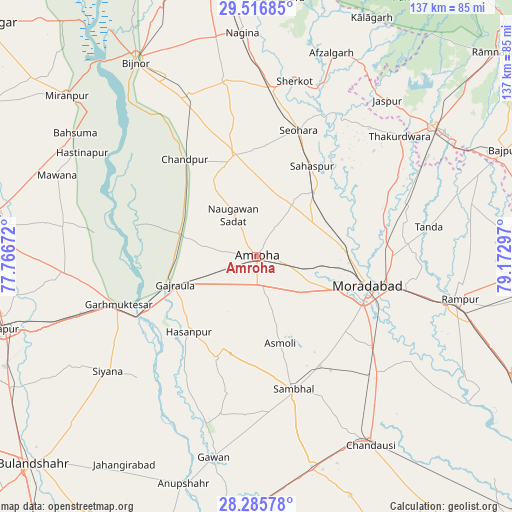
Amroha GPS coordinates[2]
28° 54' 11.304" North, 78° 28' 11.424" East
| Map corner | latitude | longitude |
|---|---|---|
| Upper-left | 29.51685°, | 77.76672° |
| Center: | 28.90314°, | 78.46984° |
| Lower-right: | 28.28578°, | 79.17297° |
| Map W x H: | 136.9×136.9 km | = 85.1×85.1mi |
| max Lat: | 34.9274° ⇑11.3% North |
| Amroha: | 28.90314° |
| min Lat: | ⇓88.7% South 8.09008° |
| min Long | Amroha | max Long |
| 68.82655° | 78.46984° | 96.81° |
| W 53.8%⇐ | ⇒46.2% E |
Elevation
Elevation of Amroha is 218 m = 715 ft, and this is 77.6 m = 255 ft below average elevation for this country.
| Max E: |
3681 m = 12077 ft | 47% |
| Avg. | 295.6 m = 970 ft | |
| Amroha | 218 m = 715 ft | |
Min E: |
1 m = 3 ft | 53% |
See also: Amroha elevation on elevation.city.
Geographical zone
Amroha is located in North temperate zone (between Tropic of Cancer and the Arctic Circle). Distance of this Northern Tropic circle is 607.8 km =377.7 mi to South.| Distance of | km | miles | from Amroha |
|---|---|---|---|
| North Pole | 6793.3 | 4221.2 | to North |
| Arctic Circle | 4187.4 | 2601.9 | to North |
| Tropic Cancer | 607.8 | 377.7 | to South |
| Equator | 3213.7 | 1996.9 | to South |


Nearby cities:
15 places around Amroha: (largest is in red/bold)
• Bachhraon
23.1 km =14.4 mi,  276°
276°
• Chāndpur
32.2 km =20 mi,  323°
323°
• Dhanaura
21.7 km =13.5 mi,  286°
286°
• Gajraula
23.3 km =14.5 mi,  254°
254°
• Garhmuktesar
38.1 km =23.7 mi, 250°
• Hasanpur
27 km =16.8 mi,  221°
221°
• Kundarkhi
39.3 km =24.4 mi,  128°
128°
• Kānth
23.3 km =14.5 mi,  41°
41°
• Morādābād
30.7 km =19.1 mi,  103°
103°
• Nūrpur
28 km =17.4 mi,  347°
347°
• Sahaspur
28.4 km =17.6 mi,  31°
31°
• Sambhal
36.7 km =22.8 mi,  164°
164°
• Seohāra
35.9 km =22.3 mi,  18°
18°
• Sirsi
33.9 km =21.1 mi,  150°
150°
• Tājpur
28.9 km =18 mi,  2°
2°
Sources, notices
• [Note1] Compared only with cities in India existing in our database
• [Src1] Map data: © OpenStreetMap contributors (CC-BY-SA)
• [Src2] Other city data from geonames.org with taken over terms of usage.
• [Src3] Geographical zone / Annual Mean Temperature by Robert A. Rohde @ Wikipedia
