Nagīna geodata
Nagīna (Uttar Pradesh) is a populated place; located in India in Asia/Kolkata (GMT+5.5) time zone. With population of 76,593 people, there are 573 cities with bigger population in this country. Compared to other cities in India, 90.8% of cities are located further ↓South; 53.4% of cities are located further ←West and 59.9% of cities have lower elevation than Nagīna. Note1


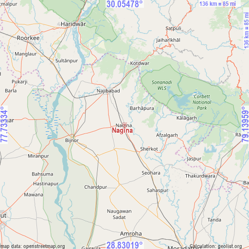
Nagīna GPS coordinates[2]
29° 26' 39.588" North, 78° 26' 11.256" East
| Map corner | latitude | longitude |
|---|---|---|
| Upper-left | 30.05478°, | 77.73334° |
| Center: | 29.44433°, | 78.43646° |
| Lower-right: | 28.83019°, | 79.13959° |
| Map W x H: | 136.2×136.2 km | = 84.6×84.6mi |
| max Lat: | 34.9274° ⇑9.2% North |
| Nagīna: | 29.44433° |
| min Lat: | ⇓90.8% South 8.09008° |
| min Long | Nagīna | max Long |
| 68.82655° | 78.43646° | 96.81° |
| W 53.4%⇐ | ⇒46.6% E |
Elevation
Elevation of Nagīna is 250 m = 820 ft, and this is 45.6 m = 150 ft below average elevation for this country.
| Max E: |
3681 m = 12077 ft | 40.1% |
| Avg. | 295.6 m = 970 ft | |
| Nagīna | 250 m = 820 ft | |
Min E: |
1 m = 3 ft | 59.9% |
See also: Nagīna elevation on elevation.city.
Geographical zone
Nagīna is located in North temperate zone (between Tropic of Cancer and the Arctic Circle). Distance of this Northern Tropic circle is 668 km =415.1 mi to South.| Distance of | km | miles | from Nagīna |
|---|---|---|---|
| North Pole | 6733.2 | 4183.8 | to North |
| Arctic Circle | 4127.3 | 2564.6 | to North |
| Tropic Cancer | 668 | 415.1 | to South |
| Equator | 3273.9 | 2034.3 | to South |


Nearby cities:
15 places around Nagīna: (largest is in red/bold)
• Afzalgarh
23.7 km =14.7 mi,  103°
103°
• Bijnor
30.1 km =18.7 mi,  254°
254°
• Dhāmpur
16.7 km =10.4 mi,  154°
154°
• Haldaur
22.6 km =14 mi,  220°
220°
• Jhālu
23.7 km =14.7 mi,  239°
239°
• Kotdwāra
34.6 km =21.5 mi,  13°
13°
• Kālāgarh Project Colony
33.9 km =21.1 mi,  83°
83°
• Kīratpur
23.3 km =14.5 mi,  287°
287°
• Mandāwar
30.3 km =18.8 mi,  278°
278°
• Najībābād
20.7 km =12.9 mi,  334°
334°
• Nihtaur
14.2 km =8.8 mi,  199°
199°
• Nūrpur
32.9 km =20.4 mi,  184°
184°
• Seohāra
30 km =18.6 mi, 150°
• Sherkot
18.7 km =11.6 mi,  134°
134°
• Tājpur
31.7 km =19.7 mi,  171°
171°
Sources, notices
• [Note1] Compared only with cities in India existing in our database
• [Src1] Map data: © OpenStreetMap contributors (CC-BY-SA)
• [Src2] Other city data from geonames.org with taken over terms of usage.
• [Src3] Geographical zone / Annual Mean Temperature by Robert A. Rohde @ Wikipedia
