Afzalgarh geodata
Afzalgarh (Uttar Pradesh) is a populated place; located in India in Asia/Kolkata (GMT+5.5) time zone. With population of 27,753 people, there are 1554 cities with bigger population in this country. Compared to other cities in India, 90.7% of cities are located further ↓South; 55.7% of cities are located further ←West and 56.9% of cities have lower elevation than Afzalgarh. Note1


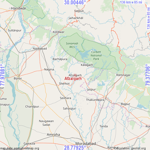
Afzalgarh GPS coordinates[2]
29° 23' 37.32" North, 78° 40' 26.148" East
| Map corner | latitude | longitude |
|---|---|---|
| Upper-left | 30.00446°, | 77.97081° |
| Center: | 29.3937°, | 78.67393° |
| Lower-right: | 28.77925°, | 79.37706° |
| Map W x H: | 136.2×136.2 km | = 84.6×84.6mi |
| max Lat: | 34.9274° ⇑9.3% North |
| Afzalgarh: | 29.3937° |
| min Lat: | ⇓90.7% South 8.09008° |
| min Long | Afzalgarh | max Long |
| 68.82655° | 78.67393° | 96.81° |
| W 55.7%⇐ | ⇒44.3% E |
Elevation
Elevation of Afzalgarh is 234 m = 768 ft, and this is 61.6 m = 202 ft below average elevation for this country.
| Max E: |
3681 m = 12077 ft | 43.1% |
| Avg. | 295.6 m = 970 ft | |
| Afzalgarh | 234 m = 768 ft | |
Min E: |
1 m = 3 ft | 56.9% |
See also: India elevation on elevation.city.
Geographical zone
Afzalgarh is located in North temperate zone (between Tropic of Cancer and the Arctic Circle). Distance of this Northern Tropic circle is 662.4 km =411.6 mi to South.| Distance of | km | miles | from Afzalgarh |
|---|---|---|---|
| North Pole | 6738.8 | 4187.3 | to North |
| Arctic Circle | 4132.9 | 2568.1 | to North |
| Tropic Cancer | 662.4 | 411.6 | to South |
| Equator | 3268.3 | 2030.8 | to South |


Nearby cities:
15 places around Afzalgarh: (largest is in red/bold)
• Dhāmpur
18.4 km =11.4 mi,  239°
239°
• Haldaur
39.5 km =24.5 mi,  253°
253°
• Jaspur
19.6 km =12.2 mi,  130°
130°
• Kashipur
33.9 km =21.1 mi, 126°
• Kālāgarh Project Colony
14.2 km =8.8 mi,  48°
48°
• Kānth
37.4 km =23.2 mi,  186°
186°
• Nagīna
23.7 km =14.7 mi,  283°
283°
• Najībābād
40.2 km =25 mi,  307°
307°
• Nihtaur
28.8 km =17.9 mi, 254°
• Nūrpur
37.4 km =23.2 mi,  223°
223°
• Sahaspur
30.7 km =19.1 mi, 189°
• Seohāra
22.1 km =13.7 mi,  202°
202°
• Sherkot
12.2 km =7.6 mi,  232°
232°
• Thakurdwara
28.9 km =18 mi,  140°
140°
• Tājpur
31.6 km =19.6 mi, 215°
Sources, notices
• [Note1] Compared only with cities in India existing in our database
• [Src1] Map data: © OpenStreetMap contributors (CC-BY-SA)
• [Src2] Other city data from geonames.org with taken over terms of usage.
• [Src3] Geographical zone / Annual Mean Temperature by Robert A. Rohde @ Wikipedia
