Kānth geodata
Kānth (Uttar Pradesh) is a populated place; located in India in Asia/Kolkata (GMT+5.5) time zone. With population of 24,883 people, there are 1713 cities with bigger population in this country. Compared to other cities in India, 89.1% of cities are located further ↓South; 55.5% of cities are located further ←West and 53.3% of cities have lower elevation than Kānth. Note1


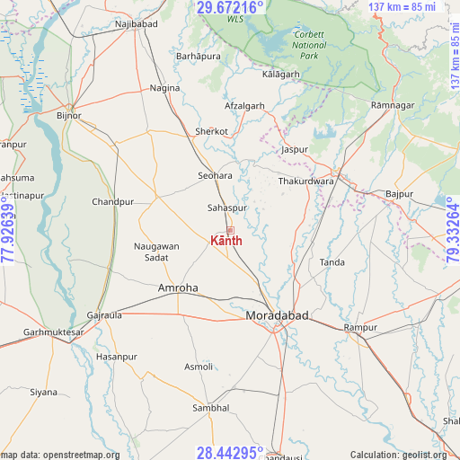
Kānth GPS coordinates[2]
29° 3' 33.804" North, 78° 37' 46.236" East
| Map corner | latitude | longitude |
|---|---|---|
| Upper-left | 29.67216°, | 77.92639° |
| Center: | 29.05939°, | 78.62951° |
| Lower-right: | 28.44295°, | 79.33264° |
| Map W x H: | 136.7×136.7 km | = 84.9×84.9mi |
| max Lat: | 34.9274° ⇑10.9% North |
| Kānth: | 29.05939° |
| min Lat: | ⇓89.1% South 8.09008° |
| min Long | Kānth | max Long |
| 68.82655° | 78.62951° | 96.81° |
| W 55.5%⇐ | ⇒44.5% E |
Elevation
Elevation of Kānth is 219 m = 719 ft, and this is 76.6 m = 251 ft below average elevation for this country.
| Max E: |
3681 m = 12077 ft | 46.7% |
| Avg. | 295.6 m = 970 ft | |
| Kānth | 219 m = 719 ft | |
Min E: |
1 m = 3 ft | 53.3% |
See also: India elevation on elevation.city.
Geographical zone
Kānth is located in North temperate zone (between Tropic of Cancer and the Arctic Circle). Distance of this Northern Tropic circle is 625.2 km =388.5 mi to South.| Distance of | km | miles | from Kānth |
|---|---|---|---|
| North Pole | 6776 | 4210.4 | to North |
| Arctic Circle | 4170.1 | 2591.2 | to North |
| Tropic Cancer | 625.2 | 388.5 | to South |
| Equator | 3231.1 | 2007.7 | to South |


Nearby cities:
15 places around Kānth: (largest is in red/bold)
• Afzalgarh
37.4 km =23.2 mi,  6°
6°
• Amroha
23.3 km =14.5 mi,  221°
221°
• Chāndpur
35.7 km =22.2 mi,  283°
283°
• Dhāmpur
30 km =18.6 mi,  337°
337°
• Jaspur
31.1 km =19.3 mi,  38°
38°
• Kashipur
36.1 km =22.4 mi,  61°
61°
• Morādābād
28.4 km =17.6 mi,  149°
149°
• Nihtaur
37.7 km =23.4 mi,  321°
321°
• Nūrpur
23.7 km =14.7 mi,  295°
295°
• Sahaspur
6.9 km =4.3 mi,  354°
354°
• Seohāra
17.1 km =10.6 mi, 346°
• Sherkot
30.2 km =18.8 mi, 349°
• Thakurdwara
26.9 km =16.7 mi, 56°
• Tājpur
18.2 km =11.3 mi,  309°
309°
• Tānda
31.7 km =19.7 mi,  106°
106°
Sources, notices
• [Note1] Compared only with cities in India existing in our database
• [Src1] Map data: © OpenStreetMap contributors (CC-BY-SA)
• [Src2] Other city data from geonames.org with taken over terms of usage.
• [Src3] Geographical zone / Annual Mean Temperature by Robert A. Rohde @ Wikipedia
