Surgāna geodata
Surgāna (Maharashtra) is a populated place; located in India in Asia/Kolkata (GMT+5.5) time zone. With population of 6,566 people, there are 3245 cities with bigger population in this country. Compared to other cities in India, 63.5% of cities are located further ↑North; 92% of cities are located further →East and 84% of cities have lower elevation than Surgāna. Note1


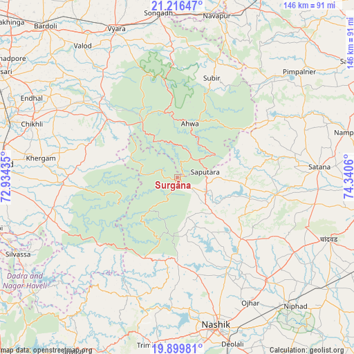
Surgāna GPS coordinates[2]
20° 33' 34.416" North, 73° 38' 14.892" East
| Map corner | latitude | longitude |
|---|---|---|
| Upper-left | 21.21647°, | 72.93435° |
| Center: | 20.55956°, | 73.63747° |
| Lower-right: | 19.89981°, | 74.3406° |
| Map W x H: | 146.4×146.4 km | = 91×91mi |
| max Lat: | 34.9274° ⇑63.5% North |
| Surgāna: | 20.55956° |
| min Lat: | ⇓36.5% South 8.09008° |
| min Long | Surgāna | max Long |
| 68.82655° | 73.63747° | 96.81° |
| W 8%⇐ | ⇒92% E |
Elevation
Elevation of Surgāna is 526 m = 1726 ft, and this is 230.4 m = 756 ft above average elevation for this country.
| Max E: |
3681 m = 12077 ft | 16% |
| Surgāna | 526 m 1726 ft | |
| Avg. | 295.6 m = 970 ft | |
Min E: |
1 m = 3 ft | 84% |
See also: India elevation on elevation.city.
Geographical zone
Surgāna is located in North Torrid zone (between Equator and Tropic of Cancer). Distance of this Northern Tropic circle is 319.9 km =198.8 mi to North.| Distance of | km | miles | from Surgāna |
|---|---|---|---|
| North Pole | 7721.1 | 4797.7 | to North |
| Arctic Circle | 5115.2 | 3178.4 | to North |
| Tropic Cancer | 319.9 | 198.8 | to North |
| Equator | 2286 | 1420.5 | to South |


Nearby cities:
15 places around Surgāna: (largest is in red/bold)
• Ahwa
22.6 km =14 mi,  13°
13°
• Chikhli
63.7 km =39.6 mi,  290°
290°
• Chāndor
68.2 km =42.4 mi,  111°
111°
• Deolāli
71.5 km =44.4 mi,  163°
163°
• Dharampur
48.4 km =30.1 mi,  267°
267°
• Nashik
64.5 km =40.1 mi,  165°
165°
• Ozar
59.9 km =37.2 mi,  149°
149°
• Parnera
71.7 km =44.6 mi, 270°
• Satānā
59 km =36.7 mi,  86°
86°
• Songadh
68.3 km =42.4 mi,  353°
353°
• Trimbak
70.6 km =43.9 mi,  189°
189°
• Vyāra
66.3 km =41.2 mi,  337°
337°
• Vānsada
36 km =22.4 mi,  307°
307°
• Waghāi
27.4 km =17 mi,  328°
328°
• Āmli
71.6 km =44.5 mi,  244°
244°
Sources, notices
• [Note1] Compared only with cities in India existing in our database
• [Src1] Map data: © OpenStreetMap contributors (CC-BY-SA)
• [Src2] Other city data from geonames.org with taken over terms of usage.
• [Src3] Geographical zone / Annual Mean Temperature by Robert A. Rohde @ Wikipedia
