Sindi geodata
Sindi (Maharashtra) is a populated place; located in India in Asia/Kolkata (GMT+5.5) time zone. With population of 13,636 people, there are 2600 cities with bigger population in this country. Compared to other cities in India, 62.5% of cities are located further ↑North; 58% of cities are located further ←West and 59.8% of cities have lower elevation than Sindi. Note1


Sindi GPS coordinates[2]
20° 48' 18.324" North, 78° 53' 15.072" East
| Map corner | latitude | longitude |
|---|---|---|
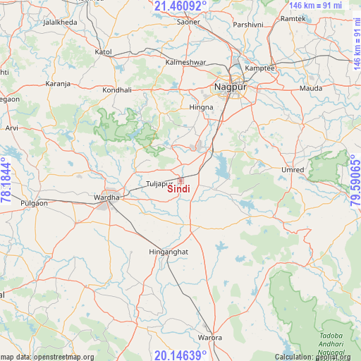
| Upper-left | 21.46092°, | 78.1844° |
| Center: | 20.80509°, | 78.88752° |
| Lower-right: | 20.14639°, | 79.59065° |
| Map W x H: | 146.2×146.2 km | = 90.8×90.8mi |
| max Lat: | 34.9274° ⇑62.5% North |
| Sindi: | 20.80509° |
| min Lat: | ⇓37.5% South 8.09008° |
| min Long | Sindi | max Long |
| 68.82655° | 78.88752° | 96.81° |
| W 58%⇐ | ⇒42% E |
Elevation
Elevation of Sindi is 249 m = 817 ft, and this is 46.6 m = 153 ft below average elevation for this country.
| Max E: |
3681 m = 12077 ft | 40.2% |
| Avg. | 295.6 m = 970 ft | |
| Sindi | 249 m = 817 ft | |
Min E: |
1 m = 3 ft | 59.8% |
See also: India elevation on elevation.city.
Geographical zone
Sindi is located in North Torrid zone (between Equator and Tropic of Cancer). Distance of this Northern Tropic circle is 292.6 km =181.8 mi to North.| Distance of | km | miles | from Sindi |
|---|---|---|---|
| North Pole | 7693.8 | 4780.7 | to North |
| Arctic Circle | 5087.9 | 3161.5 | to North |
| Tropic Cancer | 292.6 | 181.8 | to North |
| Equator | 2313.3 | 1437.4 | to South |


Nearby cities:
15 places around Sindi: (largest is in red/bold)
• Deoli
45.8 km =28.5 mi,  247°
247°
• Hinganghāt
28.9 km =18 mi,  189°
189°
• Kalmeshwar
47.6 km =29.6 mi,  4°
4°
• Khāpa
69.3 km =43.1 mi,  8°
8°
• Korādi
54.2 km =33.7 mi,  24°
24°
• Kāmthi
55.9 km =34.7 mi,  35°
35°
• Kātol
60.8 km =37.8 mi,  329°
329°
• Mohpa
56.5 km =35.1 mi,  353°
353°
• Nagpur
43.1 km =26.8 mi,  28°
28°
• Pulgaon
59.7 km =37.1 mi,  261°
261°
• Saoner
64.6 km =40.1 mi, 3°
• Sonegaon
28.2 km =17.5 mi,  226°
226°
• Umred
45.8 km =28.5 mi,  83°
83°
• Wardha
31 km =19.3 mi, 256°
• Warora
65.2 km =40.5 mi,  169°
169°
Sources, notices
• [Note1] Compared only with cities in India existing in our database
• [Src1] Map data: © OpenStreetMap contributors (CC-BY-SA)
• [Src2] Other city data from geonames.org with taken over terms of usage.
• [Src3] Geographical zone / Annual Mean Temperature by Robert A. Rohde @ Wikipedia
