Kātol geodata
Kātol (Maharashtra) is a populated place; located in India in Asia/Kolkata (GMT+5.5) time zone. With population of 41,893 people, there are 1054 cities with bigger population in this country. Compared to other cities in India, 60.2% of cities are located further ↑North; 55% of cities are located further ←West and 76.9% of cities have lower elevation than Kātol. Note1


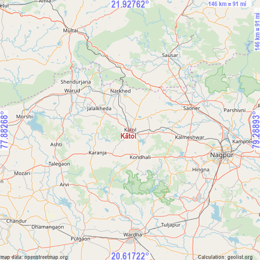
Kātol GPS coordinates[2]
21° 16' 25.968" North, 78° 35' 8.88" East
| Map corner | latitude | longitude |
|---|---|---|
| Upper-left | 21.92762°, | 77.88268° |
| Center: | 21.27388°, | 78.5858° |
| Lower-right: | 20.61722°, | 79.28893° |
| Map W x H: | 145.7×145.7 km | = 90.5×90.5mi |
| max Lat: | 34.9274° ⇑60.2% North |
| Kātol: | 21.27388° |
| min Lat: | ⇓39.8% South 8.09008° |
| min Long | Kātol | max Long |
| 68.82655° | 78.5858° | 96.81° |
| W 55%⇐ | ⇒45% E |
Elevation
Elevation of Kātol is 413 m = 1355 ft, and this is 117.4 m = 385 ft above average elevation for this country.
| Max E: |
3681 m = 12077 ft | 23.1% |
| Kātol | 413 m 1355 ft | |
| Avg. | 295.6 m = 970 ft | |
Min E: |
1 m = 3 ft | 76.9% |
See also: Kātol elevation on elevation.city.
Geographical zone
Kātol is located in North Torrid zone (between Equator and Tropic of Cancer). Distance of this Northern Tropic circle is 240.5 km =149.4 mi to North.| Distance of | km | miles | from Kātol |
|---|---|---|---|
| North Pole | 7641.6 | 4748.3 | to North |
| Arctic Circle | 5035.7 | 3129 | to North |
| Tropic Cancer | 240.5 | 149.4 | to North |
| Equator | 2365.4 | 1469.8 | to South |


Nearby cities:
15 places around Kātol: (largest is in red/bold)
• Kalmeshwar
34.9 km =21.7 mi,  97°
97°
• Khāpa
44.2 km =27.5 mi,  68°
68°
• Korādi
54 km =33.6 mi,  93°
93°
• Lodhīkheda
44.5 km =27.7 mi,  39°
39°
• Mohgaon
43.5 km =27 mi,  20°
20°
• Mohpa
25.6 km =15.9 mi,  80°
80°
• Morsi
59.8 km =37.2 mi,  277°
277°
• Mowād
25.4 km =15.8 mi,  326°
326°
• Nagpur
53.6 km =33.3 mi,  105°
105°
• Pāndhurnā
36.3 km =22.6 mi,  350°
350°
• Saoner
36.9 km =22.9 mi, 70°
• Sausar
47.7 km =29.6 mi,  27°
27°
• Wardha
59.4 km =36.9 mi,  178°
178°
• Warud
39.4 km =24.5 mi,  303°
303°
• Ārvi
48.2 km =30 mi,  230°
230°
Sources, notices
• [Note1] Compared only with cities in India existing in our database
• [Src1] Map data: © OpenStreetMap contributors (CC-BY-SA)
• [Src2] Other city data from geonames.org with taken over terms of usage.
• [Src3] Geographical zone / Annual Mean Temperature by Robert A. Rohde @ Wikipedia
