Umred geodata
Umred (Maharashtra) is a populated place; located in India in Asia/Kolkata (GMT+5.5) time zone. With population of 51,794 people, there are 861 cities with bigger population in this country. Compared to other cities in India, 62.2% of cities are located further ↑North; 62.1% of cities are located further ←West and 65.4% of cities have lower elevation than Umred. Note1


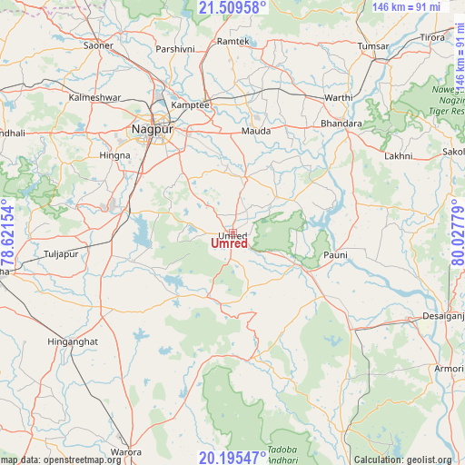
Umred GPS coordinates[2]
20° 51' 14.256" North, 79° 19' 28.776" East
| Map corner | latitude | longitude |
|---|---|---|
| Upper-left | 21.50958°, | 78.62154° |
| Center: | 20.85396°, | 79.32466° |
| Lower-right: | 20.19547°, | 80.02779° |
| Map W x H: | 146.1×146.1 km | = 90.8×90.8mi |
| max Lat: | 34.9274° ⇑62.2% North |
| Umred: | 20.85396° |
| min Lat: | ⇓37.8% South 8.09008° |
| min Long | Umred | max Long |
| 68.82655° | 79.32466° | 96.81° |
| W 62.1%⇐ | ⇒37.9% E |
Elevation
Elevation of Umred is 289 m = 948 ft, and this is 6.6 m = 22 ft below average elevation for this country.
| Max E: |
3681 m = 12077 ft | 34.6% |
| Avg. | 295.6 m = 970 ft | |
| Umred | 289 m = 948 ft | |
Min E: |
1 m = 3 ft | 65.4% |
See also: Umred elevation on elevation.city.
Geographical zone
Umred is located in North Torrid zone (between Equator and Tropic of Cancer). Distance of this Northern Tropic circle is 287.2 km =178.5 mi to North.| Distance of | km | miles | from Umred |
|---|---|---|---|
| North Pole | 7688.3 | 4777.3 | to North |
| Arctic Circle | 5082.4 | 3158.1 | to North |
| Tropic Cancer | 287.2 | 178.5 | to North |
| Equator | 2318.7 | 1440.8 | to South |


Nearby cities:
15 places around Umred: (largest is in red/bold)
• Bhandāra
48.5 km =30.1 mi,  43°
43°
• Hinganghāt
60.8 km =37.8 mi,  236°
236°
• Kalmeshwar
59.4 km =36.9 mi,  315°
315°
• Korādi
49.3 km =30.6 mi,  332°
332°
• Kāmthi
42.4 km =26.3 mi,  341°
341°
• Kāndri
63.2 km =39.3 mi,  355°
355°
• Mansar
60.6 km =37.7 mi,  353°
353°
• Mohpa
72.2 km =44.9 mi,  314°
314°
• Nagpur
40.9 km =25.4 mi, 322°
• Pawni
33.1 km =20.6 mi,  101°
101°
• Rāmtek
60.2 km =37.4 mi,  0°
0°
• Saoner
72.4 km =45 mi, 324°
• Sindi
45.8 km =28.5 mi,  263°
263°
• Sonegaon
70.4 km =43.7 mi,  249°
249°
• Tumsar
72.5 km =45 mi, 35°
Sources, notices
• [Note1] Compared only with cities in India existing in our database
• [Src1] Map data: © OpenStreetMap contributors (CC-BY-SA)
• [Src2] Other city data from geonames.org with taken over terms of usage.
• [Src3] Geographical zone / Annual Mean Temperature by Robert A. Rohde @ Wikipedia
