Warora geodata
Warora (Maharashtra) is a populated place; located in India in Asia/Kolkata (GMT+5.5) time zone. With population of 41,523 people, there are 1066 cities with bigger population in this country. Compared to other cities in India, 64.5% of cities are located further ↑North; 59% of cities are located further ←West and 51.1% of cities have lower elevation than Warora. Note1


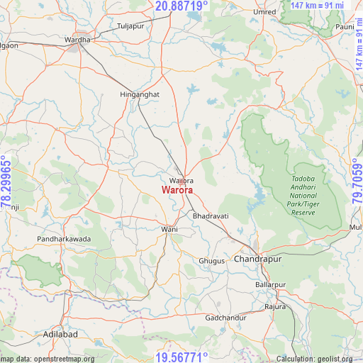
Warora GPS coordinates[2]
20° 13' 43.86" North, 79° 0' 9.972" East
| Map corner | latitude | longitude |
|---|---|---|
| Upper-left | 20.88719°, | 78.29965° |
| Center: | 20.22885°, | 79.00277° |
| Lower-right: | 19.56771°, | 79.7059° |
| Map W x H: | 146.7×146.7 km | = 91.2×91.2mi |
| max Lat: | 34.9274° ⇑64.5% North |
| Warora: | 20.22885° |
| min Lat: | ⇓35.5% South 8.09008° |
| min Long | Warora | max Long |
| 68.82655° | 79.00277° | 96.81° |
| W 59%⇐ | ⇒41% E |
Elevation
Elevation of Warora is 208 m = 682 ft, and this is 87.6 m = 287 ft below average elevation for this country.
| Max E: |
3681 m = 12077 ft | 48.9% |
| Avg. | 295.6 m = 970 ft | |
| Warora | 208 m = 682 ft | |
Min E: |
1 m = 3 ft | 51.1% |
See also: Warora elevation on elevation.city.
Geographical zone
Warora is located in North Torrid zone (between Equator and Tropic of Cancer). Distance of this Northern Tropic circle is 356.7 km =221.6 mi to North.| Distance of | km | miles | from Warora |
|---|---|---|---|
| North Pole | 7757.8 | 4820.5 | to North |
| Arctic Circle | 5151.9 | 3201.2 | to North |
| Tropic Cancer | 356.7 | 221.6 | to North |
| Equator | 2249.2 | 1397.6 | to South |


Nearby cities:
15 places around Warora: (largest is in red/bold)
• Ballālpur
55.6 km =34.5 mi,  139°
139°
• Chānda
43.5 km =27 mi, 135°
• Chāndur
57.7 km =35.9 mi,  162°
162°
• Deoli
71.8 km =44.6 mi,  310°
310°
• Durgāpur
40 km =24.9 mi,  128°
128°
• Ghugus
34.3 km =21.3 mi, 160°
• Ghātanji
72.6 km =45.1 mi,  262°
262°
• Hinganghāt
39.4 km =24.5 mi,  334°
334°
• Mūl
72.7 km =45.2 mi,  104°
104°
• Rājur
17.4 km =10.8 mi,  221°
221°
• Rājūra
62.7 km =39 mi, 142°
• Sindi
65.2 km =40.5 mi,  349°
349°
• Sonegaon
55 km =34.2 mi,  323°
323°
• Wani
20 km =12.4 mi,  195°
195°
• Wardha
70.7 km =43.9 mi, 323°
Sources, notices
• [Note1] Compared only with cities in India existing in our database
• [Src1] Map data: © OpenStreetMap contributors (CC-BY-SA)
• [Src2] Other city data from geonames.org with taken over terms of usage.
• [Src3] Geographical zone / Annual Mean Temperature by Robert A. Rohde @ Wikipedia
