Nagpur geodata
Nagpur (Maharashtra) is a seat of a second-order administrative division; located in India in Asia/Kolkata (GMT+5.5) time zone. With population of 2,228,018 people, there are 13 cities with bigger population in this country. Compared to other cities in India, 61% of cities are located further ↑North; 59.7% of cities are located further ←West and 69.2% of cities have lower elevation than Nagpur. Note1


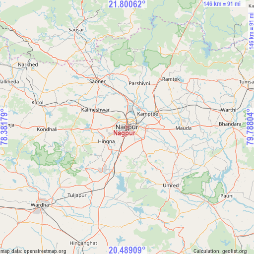
Nagpur GPS coordinates[2]
21° 8' 46.716" North, 79° 5' 5.676" East
| Map corner | latitude | longitude |
|---|---|---|
| Upper-left | 21.80062°, | 78.38179° |
| Center: | 21.14631°, | 79.08491° |
| Lower-right: | 20.48909°, | 79.78804° |
| Map W x H: | 145.8×145.8 km | = 90.6×90.6mi |
| max Lat: | 34.9274° ⇑61% North |
| Nagpur: | 21.14631° |
| min Lat: | ⇓39% South 8.09008° |
| min Long | Nagpur | max Long |
| 68.82655° | 79.08491° | 96.81° |
| W 59.7%⇐ | ⇒40.3% E |
Elevation
Elevation of Nagpur is 319 m = 1047 ft, and this is 23.4 m = 77 ft above average elevation for this country.
| Max E: |
3681 m = 12077 ft | 30.8% |
| Nagpur | 319 m 1047 ft | |
| Avg. | 295.6 m = 970 ft | |
Min E: |
1 m = 3 ft | 69.2% |
See also: Nagpur elevation on elevation.city.
Geographical zone
Nagpur is located in North Torrid zone (between Equator and Tropic of Cancer). Distance of this Northern Tropic circle is 254.7 km =158.3 mi to North.| Distance of | km | miles | from Nagpur |
|---|---|---|---|
| North Pole | 7655.8 | 4757.1 | to North |
| Arctic Circle | 5049.9 | 3137.9 | to North |
| Tropic Cancer | 254.7 | 158.3 | to North |
| Equator | 2351.2 | 1461 | to South |


Nearby cities:
15 places around Nagpur: (largest is in red/bold)
• Bhandāra
58.5 km =36.4 mi,  87°
87°
• Kalmeshwar
19.6 km =12.2 mi,  299°
299°
• Khāpa
32.5 km =20.2 mi,  340°
340°
• Korādi
11.5 km =7.1 mi,  10°
10°
• Kāmthi
14 km =8.7 mi,  56°
56°
• Kāndri
36.4 km =22.6 mi,  33°
33°
• Kātol
53.6 km =33.3 mi,  285°
285°
• Lodhīkheda
53.8 km =33.4 mi,  334°
334°
• Mansar
33.4 km =20.8 mi, 33°
• Mohpa
32.1 km =19.9 mi, 304°
• Rāmtek
37.4 km =23.2 mi,  42°
42°
• Saoner
31.5 km =19.6 mi, 327°
• Sausar
64 km =39.8 mi, 332°
• Sindi
43.1 km =26.8 mi,  208°
208°
• Umred
40.9 km =25.4 mi,  142°
142°
Sources, notices
• [Note1] Compared only with cities in India existing in our database
• [Src1] Map data: © OpenStreetMap contributors (CC-BY-SA)
• [Src2] Other city data from geonames.org with taken over terms of usage.
• [Src3] Geographical zone / Annual Mean Temperature by Robert A. Rohde @ Wikipedia
