Kāmthi geodata
Kāmthi (Maharashtra) is a populated place; located in India in Asia/Kolkata (GMT+5.5) time zone. With population of 86,213 people, there are 519 cities with bigger population in this country. Compared to other cities in India, 60.6% of cities are located further ↑North; 61% of cities are located further ←West and 65.4% of cities have lower elevation than Kāmthi. Note1


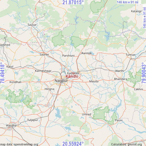
Kāmthi GPS coordinates[2]
21° 12' 58.14" North, 79° 11' 50.28" East
| Map corner | latitude | longitude |
|---|---|---|
| Upper-left | 21.87015°, | 78.49418° |
| Center: | 21.21615°, | 79.1973° |
| Lower-right: | 20.55924°, | 79.90043° |
| Map W x H: | 145.8×145.8 km | = 90.6×90.6mi |
| max Lat: | 34.9274° ⇑60.6% North |
| Kāmthi: | 21.21615° |
| min Lat: | ⇓39.4% South 8.09008° |
| min Long | Kāmthi | max Long |
| 68.82655° | 79.1973° | 96.81° |
| W 61%⇐ | ⇒39% E |
Elevation
Elevation of Kāmthi is 288 m = 945 ft, and this is 7.6 m = 25 ft below average elevation for this country.
| Max E: |
3681 m = 12077 ft | 34.6% |
| Avg. | 295.6 m = 970 ft | |
| Kāmthi | 288 m = 945 ft | |
Min E: |
1 m = 3 ft | 65.4% |
See also: Kāmthi elevation on elevation.city.
Geographical zone
Kāmthi is located in North Torrid zone (between Equator and Tropic of Cancer). Distance of this Northern Tropic circle is 246.9 km =153.4 mi to North.| Distance of | km | miles | from Kāmthi |
|---|---|---|---|
| North Pole | 7648 | 4752.2 | to North |
| Arctic Circle | 5042.2 | 3133.1 | to North |
| Tropic Cancer | 246.9 | 153.4 | to North |
| Equator | 2359 | 1465.8 | to South |


Nearby cities:
15 places around Kāmthi: (largest is in red/bold)
• Bhandāra
47.1 km =29.3 mi,  96°
96°
• Chicholi
59.3 km =36.8 mi,  61°
61°
• Kalmeshwar
28.8 km =17.9 mi,  273°
273°
• Khāpa
32 km =19.9 mi,  315°
315°
• Korādi
10.1 km =6.3 mi,  290°
290°
• Kāndri
24.1 km =15 mi,  19°
19°
• Lodhīkheda
53.7 km =33.4 mi, 319°
• Mansar
21.1 km =13.1 mi, 18°
• Mohpa
39.5 km =24.5 mi, 285°
• Nagpur
14 km =8.7 mi,  236°
236°
• Rāmtek
24.1 km =15 mi,  34°
34°
• Saoner
34.2 km =21.3 mi,  303°
303°
• Sindi
55.9 km =34.7 mi,  215°
215°
• Tumsar
58.6 km =36.4 mi,  71°
71°
• Umred
42.4 km =26.3 mi,  161°
161°
Sources, notices
• [Note1] Compared only with cities in India existing in our database
• [Src1] Map data: © OpenStreetMap contributors (CC-BY-SA)
• [Src2] Other city data from geonames.org with taken over terms of usage.
• [Src3] Geographical zone / Annual Mean Temperature by Robert A. Rohde @ Wikipedia
