Hāngal geodata
Hāngal (Karnataka) is a populated place; located in India in Asia/Kolkata (GMT+5.5) time zone. With population of 26,604 people, there are 1605 cities with bigger population in this country. Compared to other cities in India, 82% of cities are located further ↑North; 81.7% of cities are located further →East and 87.5% of cities have lower elevation than Hāngal. Note1


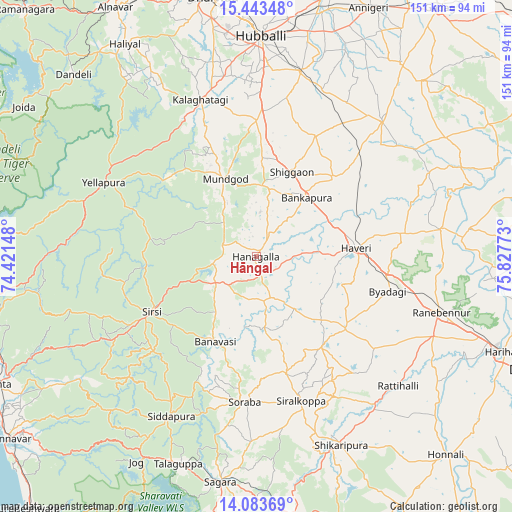
Hāngal GPS coordinates[2]
14° 45' 52.74" North, 75° 7' 28.56" East
| Map corner | latitude | longitude |
|---|---|---|
| Upper-left | 15.44348°, | 74.42148° |
| Center: | 14.76465°, | 75.1246° |
| Lower-right: | 14.08369°, | 75.82773° |
| Map W x H: | 151.2×151.2 km | = 94×94mi |
| max Lat: | 34.9274° ⇑82% North |
| Hāngal: | 14.76465° |
| min Lat: | ⇓18% South 8.09008° |
| min Long | Hāngal | max Long |
| 68.82655° | 75.1246° | 96.81° |
| W 18.3%⇐ | ⇒81.7% E |
Elevation
Elevation of Hāngal is 586 m = 1923 ft, and this is 290.4 m = 953 ft above average elevation for this country.
| Max E: |
3681 m = 12077 ft | 12.5% |
| Hāngal | 586 m 1923 ft | |
| Avg. | 295.6 m = 970 ft | |
Min E: |
1 m = 3 ft | 87.5% |
See also: India elevation on elevation.city.
Geographical zone
Hāngal is located in North Torrid zone (between Equator and Tropic of Cancer). Distance of this Northern Tropic circle is 964.2 km =599.1 mi to North.| Distance of | km | miles | from Hāngal |
|---|---|---|---|
| North Pole | 8365.4 | 5198 | to North |
| Arctic Circle | 5759.5 | 3578.8 | to North |
| Tropic Cancer | 964.2 | 599.1 | to North |
| Equator | 1641.7 | 1020.1 | to South |


Nearby cities:
15 places around Hāngal: (largest is in red/bold)
• Byādgi
40.3 km =25 mi,  104°
104°
• Hirekerūr
45.1 km =28 mi,  139°
139°
• Hāveri
30.3 km =18.8 mi,  83°
83°
• Kalghatgi
49.4 km =30.7 mi,  340°
340°
• Kundgol
56.2 km =34.9 mi,  13°
13°
• Lakshmeshwar
54.7 km =34 mi,  42°
42°
• Mundgod
24.9 km =15.5 mi, 337°
• Rānībennur
56.6 km =35.2 mi,  106°
106°
• Savanūr
32.6 km =20.3 mi, 44°
• Shiggaon
27.3 km =17 mi,  23°
23°
• Shikārpur
60.4 km =37.5 mi,  155°
155°
• Siddāpur
53 km =32.9 mi,  207°
207°
• Sirsi
35 km =21.7 mi,  242°
242°
• Sorab
42.8 km =26.6 mi,  184°
184°
• Yellāpur
49.8 km =30.9 mi,  296°
296°
Sources, notices
• [Note1] Compared only with cities in India existing in our database
• [Src1] Map data: © OpenStreetMap contributors (CC-BY-SA)
• [Src2] Other city data from geonames.org with taken over terms of usage.
• [Src3] Geographical zone / Annual Mean Temperature by Robert A. Rohde @ Wikipedia
