Byādgi geodata
Byādgi (Karnataka) is a populated place; located in India in Asia/Kolkata (GMT+5.5) time zone. With population of 27,719 people, there are 1555 cities with bigger population in this country. Compared to other cities in India, 82.1% of cities are located further ↑North; 78.6% of cities are located further →East and 89% of cities have lower elevation than Byādgi. Note1


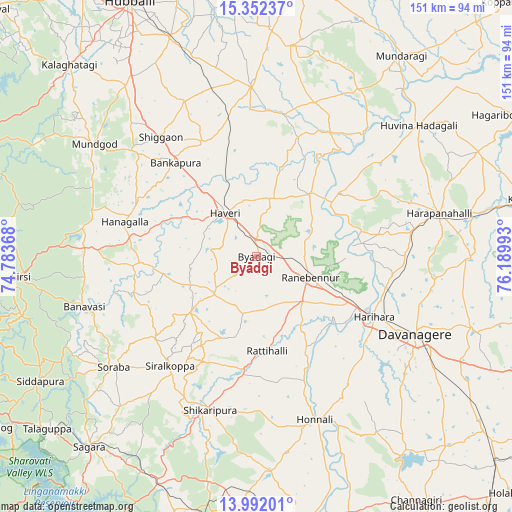
Byādgi GPS coordinates[2]
14° 40' 23.7" North, 75° 29' 12.48" East
| Map corner | latitude | longitude |
|---|---|---|
| Upper-left | 15.35237°, | 74.78368° |
| Center: | 14.67325°, | 75.4868° |
| Lower-right: | 13.99201°, | 76.18993° |
| Map W x H: | 151.3×151.3 km | = 94×94mi |
| max Lat: | 34.9274° ⇑82.1% North |
| Byādgi: | 14.67325° |
| min Lat: | ⇓17.9% South 8.09008° |
| min Long | Byādgi | max Long |
| 68.82655° | 75.4868° | 96.81° |
| W 21.4%⇐ | ⇒78.6% E |
Elevation
Elevation of Byādgi is 613 m = 2011 ft, and this is 317.4 m = 1041 ft above average elevation for this country.
| Max E: |
3681 m = 12077 ft | 11% |
| Byādgi | 613 m 2011 ft | |
| Avg. | 295.6 m = 970 ft | |
Min E: |
1 m = 3 ft | 89% |
See also: India elevation on elevation.city.
Geographical zone
Byādgi is located in North Torrid zone (between Equator and Tropic of Cancer). Distance of this Northern Tropic circle is 974.4 km =605.5 mi to North.| Distance of | km | miles | from Byādgi |
|---|---|---|---|
| North Pole | 8375.5 | 5204.3 | to North |
| Arctic Circle | 5769.7 | 3585.1 | to North |
| Tropic Cancer | 974.4 | 605.5 | to North |
| Equator | 1631.5 | 1013.8 | to South |


Nearby cities:
15 places around Byādgi: (largest is in red/bold)
• Davangere
52.6 km =32.7 mi,  115°
115°
• Harihar
38.8 km =24.1 mi, 117°
• Harpanahalli
55.4 km =34.4 mi,  76°
76°
• Hirekerūr
26.2 km =16.3 mi,  202°
202°
• Honnāli
51.1 km =31.8 mi,  160°
160°
• Hāngal
40.3 km =25 mi,  284°
284°
• Hāveri
16 km =9.9 mi,  326°
326°
• Lakshmeshwar
50.5 km =31.4 mi,  357°
357°
• Mundgod
58.7 km =36.5 mi,  304°
304°
• Nyāmti
59.1 km =36.7 mi,  170°
170°
• Rānībennur
16.4 km =10.2 mi,  110°
110°
• Savanūr
37 km =23 mi, 334°
• Shiggaon
45.1 km =28 mi,  321°
321°
• Shikārpur
47 km =29.2 mi, 197°
• Sorab
53.5 km =33.2 mi,  232°
232°
Sources, notices
• [Note1] Compared only with cities in India existing in our database
• [Src1] Map data: © OpenStreetMap contributors (CC-BY-SA)
• [Src2] Other city data from geonames.org with taken over terms of usage.
• [Src3] Geographical zone / Annual Mean Temperature by Robert A. Rohde @ Wikipedia
