Yellāpur geodata
Yellāpur (Karnataka) is a populated place; located in India in Asia/Kolkata (GMT+5.5) time zone. With population of 19,343 people, there are 2094 cities with bigger population in this country. Compared to other cities in India, 81.7% of cities are located further ↑North; 85.2% of cities are located further →East and 85.7% of cities have lower elevation than Yellāpur. Note1


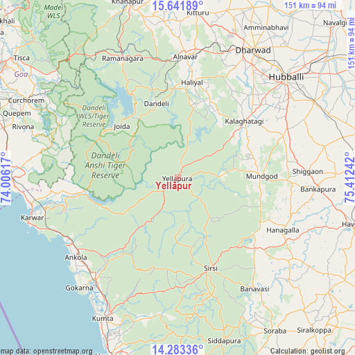
Yellāpur GPS coordinates[2]
14° 57' 49.32" North, 74° 42' 33.444" East
| Map corner | latitude | longitude |
|---|---|---|
| Upper-left | 15.64189°, | 74.00617° |
| Center: | 14.9637°, | 74.70929° |
| Lower-right: | 14.28336°, | 75.41242° |
| Map W x H: | 151.1×151.1 km | = 93.9×93.9mi |
| max Lat: | 34.9274° ⇑81.7% North |
| Yellāpur: | 14.9637° |
| min Lat: | ⇓18.3% South 8.09008° |
| min Long | Yellāpur | max Long |
| 68.82655° | 74.70929° | 96.81° |
| W 14.8%⇐ | ⇒85.2% E |
Elevation
Elevation of Yellāpur is 559 m = 1834 ft, and this is 263.4 m = 864 ft above average elevation for this country.
| Max E: |
3681 m = 12077 ft | 14.3% |
| Yellāpur | 559 m 1834 ft | |
| Avg. | 295.6 m = 970 ft | |
Min E: |
1 m = 3 ft | 85.7% |
See also: India elevation on elevation.city.
Geographical zone
Yellāpur is located in North Torrid zone (between Equator and Tropic of Cancer). Distance of this Northern Tropic circle is 942.1 km =585.4 mi to North.| Distance of | km | miles | from Yellāpur |
|---|---|---|---|
| North Pole | 8343.3 | 5184.3 | to North |
| Arctic Circle | 5737.4 | 3565.1 | to North |
| Tropic Cancer | 942.1 | 585.4 | to North |
| Equator | 1663.8 | 1033.8 | to South |


Nearby cities:
15 places around Yellāpur: (largest is in red/bold)
• Alnāvar
51.7 km =32.1 mi,  3°
3°
• Ankola
55 km =34.2 mi,  232°
232°
• Dandeli
35.1 km =21.8 mi,  343°
343°
• Gokarna
62.4 km =38.8 mi,  222°
222°
• Haliyal
40.9 km =25.4 mi,  7°
7°
• Hubli
62.4 km =38.8 mi,  46°
46°
• Hāngal
49.8 km =30.9 mi,  116°
116°
• Kalghatgi
37.2 km =23.1 mi, 49°
• Karwar
64.5 km =40.1 mi,  254°
254°
• Kundgol
66.3 km =41.2 mi,  60°
60°
• Londa
59.8 km =37.2 mi, 340°
• Mundgod
35.2 km =21.9 mi,  88°
88°
• Sanguem
66.8 km =41.5 mi,  296°
296°
• Shiggaon
55.5 km =34.5 mi, 86°
• Sirsi
40.5 km =25.2 mi,  160°
160°
Sources, notices
• [Note1] Compared only with cities in India existing in our database
• [Src1] Map data: © OpenStreetMap contributors (CC-BY-SA)
• [Src2] Other city data from geonames.org with taken over terms of usage.
• [Src3] Geographical zone / Annual Mean Temperature by Robert A. Rohde @ Wikipedia
