Dasūya geodata
Dasūya (Punjab) is a populated place; located in India in Asia/Kolkata (GMT+5.5) time zone. With population of 20,697 people, there are 1990 cities with bigger population in this country. Compared to other cities in India, 97.5% of cities are located further ↓South; 77% of cities are located further →East and 61.3% of cities have lower elevation than Dasūya. Note1


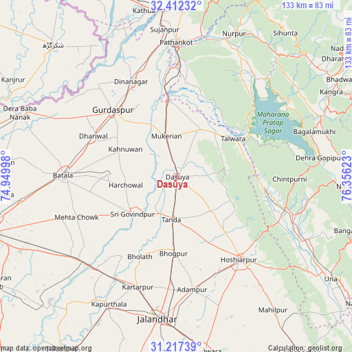
Dasūya GPS coordinates[2]
31° 49' 0.444" North, 75° 39' 11.16" East
| Map corner | latitude | longitude |
|---|---|---|
| Upper-left | 32.41232°, | 74.94998° |
| Center: | 31.81679°, | 75.6531° |
| Lower-right: | 31.21739°, | 76.35623° |
| Map W x H: | 132.9×132.9 km | = 82.6×82.6mi |
| max Lat: | 34.9274° ⇑2.5% North |
| Dasūya: | 31.81679° |
| min Lat: | ⇓97.5% South 8.09008° |
| min Long | Dasūya | max Long |
| 68.82655° | 75.6531° | 96.81° |
| W 23%⇐ | ⇒77% E |
Elevation
Elevation of Dasūya is 260 m = 853 ft, and this is 35.6 m = 117 ft below average elevation for this country.
| Max E: |
3681 m = 12077 ft | 38.7% |
| Avg. | 295.6 m = 970 ft | |
| Dasūya | 260 m = 853 ft | |
Min E: |
1 m = 3 ft | 61.3% |
See also: India elevation on elevation.city.
Geographical zone
Dasūya is located in North temperate zone (between Tropic of Cancer and the Arctic Circle). Distance of this Northern Tropic circle is 931.8 km =579 mi to South.| Distance of | km | miles | from Dasūya |
|---|---|---|---|
| North Pole | 6469.4 | 4019.9 | to North |
| Arctic Circle | 3863.5 | 2400.7 | to North |
| Tropic Cancer | 931.8 | 579 | to South |
| Equator | 3537.7 | 2198.2 | to South |


Nearby cities:
15 places around Dasūya: (largest is in red/bold)
• Begowāl
26 km =16.2 mi,  208°
208°
• Bhogpur
29.2 km =18.1 mi,  181°
181°
• Bhulath Gharbi
33.4 km =20.8 mi,  204°
204°
• Daulatpur
32.1 km =19.9 mi,  95°
95°
• Dhāriwāl
34.7 km =21.6 mi,  296°
296°
• Dīnānagar
39.4 km =24.5 mi,  334°
334°
• Gagret
42.4 km =26.3 mi,  114°
114°
• Garhdiwāla
12.8 km =8 mi,  130°
130°
• Hariāna
26.8 km =16.7 mi,  138°
138°
• Hoshiārpur
39.6 km =24.6 mi, 141°
• Hājipur
20.2 km =12.6 mi,  28°
28°
• Mukeriān
15.6 km =9.7 mi,  347°
347°
• Qādiān
26.1 km =16.2 mi,  271°
271°
• Shām Churāsi
36.3 km =22.6 mi,  165°
165°
• Talwāra
25.8 km =16 mi,  58°
58°
Sources, notices
• [Note1] Compared only with cities in India existing in our database
• [Src1] Map data: © OpenStreetMap contributors (CC-BY-SA)
• [Src2] Other city data from geonames.org with taken over terms of usage.
• [Src3] Geographical zone / Annual Mean Temperature by Robert A. Rohde @ Wikipedia
