Gagret geodata
Gagret (Himachal Pradesh) is a populated place; located in India in Asia/Kolkata (GMT+5.5) time zone. With population of 3,025 people, there are 3411 cities with bigger population in this country. Compared to other cities in India, 97.2% of cities are located further ↓South; 73% of cities are located further →East and 80.7% of cities have lower elevation than Gagret. Note1


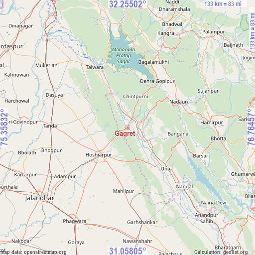
Gagret GPS coordinates[2]
31° 39' 30.456" North, 76° 3' 41.184" East
| Map corner | latitude | longitude |
|---|---|---|
| Upper-left | 32.25502°, | 75.35832° |
| Center: | 31.65846°, | 76.06144° |
| Lower-right: | 31.05805°, | 76.76457° |
| Map W x H: | 133.1×133.1 km | = 82.7×82.7mi |
| max Lat: | 34.9274° ⇑2.8% North |
| Gagret: | 31.65846° |
| min Lat: | ⇓97.2% South 8.09008° |
| min Long | Gagret | max Long |
| 68.82655° | 76.06144° | 96.81° |
| W 27%⇐ | ⇒73% E |
Elevation
Elevation of Gagret is 470 m = 1542 ft, and this is 174.4 m = 572 ft above average elevation for this country.
| Max E: |
3681 m = 12077 ft | 19.3% |
| Gagret | 470 m 1542 ft | |
| Avg. | 295.6 m = 970 ft | |
Min E: |
1 m = 3 ft | 80.7% |
See also: India elevation on elevation.city.
Geographical zone
Gagret is located in North temperate zone (between Tropic of Cancer and the Arctic Circle). Distance of this Northern Tropic circle is 914.2 km =568.1 mi to South.| Distance of | km | miles | from Gagret |
|---|---|---|---|
| North Pole | 6487 | 4030.8 | to North |
| Arctic Circle | 3881.1 | 2411.6 | to North |
| Tropic Cancer | 914.2 | 568.1 | to South |
| Equator | 3520.1 | 2187.3 | to South |


Nearby cities:
15 places around Gagret: (largest is in red/bold)
• Adampur
41.4 km =25.7 mi,  232°
232°
• Bhogpur
41.3 km =25.7 mi,  253°
253°
• Dasūya
42.4 km =26.3 mi,  294°
294°
• Daulatpur
15.9 km =9.9 mi,  335°
335°
• Dera Gopipur
28.7 km =17.8 mi,  31°
31°
• Garhdiwāla
30.4 km =18.9 mi, 287°
• Hariāna
21.2 km =13.2 mi,  262°
262°
• Hoshiārpur
19.5 km =12.1 mi, 226°
• Jawāla Mukhi
34.3 km =21.3 mi,  45°
45°
• Nangal
42.2 km =26.2 mi,  135°
135°
• Nādaun
30 km =18.6 mi,  62°
62°
• Santokhgarh
41.8 km =26 mi, 144°
• Shām Churāsi
34.4 km =21.4 mi,  239°
239°
• Talwāra
35.2 km =21.9 mi,  331°
331°
• Una
29.2 km =18.1 mi, 137°
Sources, notices
• [Note1] Compared only with cities in India existing in our database
• [Src1] Map data: © OpenStreetMap contributors (CC-BY-SA)
• [Src2] Other city data from geonames.org with taken over terms of usage.
• [Src3] Geographical zone / Annual Mean Temperature by Robert A. Rohde @ Wikipedia
