Dhrol geodata
Dhrol (Gujarat) is a populated place; located in India in Asia/Kolkata (GMT+5.5) time zone. With population of 26,496 people, there are 1610 cities with bigger population in this country. Compared to other cities in India, 52.5% of cities are located further ↑North; 99.1% of cities are located further →East and 83.9% of cities have higher elevation than Dhrol. Note1


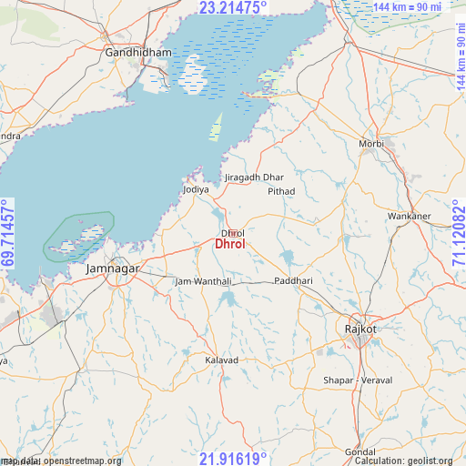
Dhrol GPS coordinates[2]
22° 34' 1.2" North, 70° 25' 3.684" East
| Map corner | latitude | longitude |
|---|---|---|
| Upper-left | 23.21475°, | 69.71457° |
| Center: | 22.567°, | 70.41769° |
| Lower-right: | 21.91619°, | 71.12082° |
| Map W x H: | 144.4×144.4 km | = 89.7×89.7mi |
| max Lat: | 34.9274° ⇑52.5% North |
| Dhrol: | 22.567° |
| min Lat: | ⇓47.5% South 8.09008° |
| min Long | Dhrol | max Long |
| 68.82655° | 70.41769° | 96.81° |
| W 0.9%⇐ | ⇒99.1% E |
Elevation
Elevation of Dhrol is 34 m = 112 ft, and this is 261.6 m = 858 ft below average elevation for this country.
| Max E: |
3681 m = 12077 ft | 83.9% |
| Avg. | 295.6 m = 970 ft | |
| Dhrol | 34 m = 112 ft | |
Min E: |
1 m = 3 ft | 16.1% |
See also: India elevation on elevation.city.
Geographical zone
Dhrol is located in North Torrid zone (between Equator and Tropic of Cancer). Distance of this Northern Tropic circle is 96.7 km =60.1 mi to North.| Distance of | km | miles | from Dhrol |
|---|---|---|---|
| North Pole | 7497.8 | 4658.9 | to North |
| Arctic Circle | 4892 | 3039.7 | to North |
| Tropic Cancer | 96.7 | 60.1 | to North |
| Equator | 2509.2 | 1559.1 | to South |


Nearby cities:
15 places around Dhrol: (largest is in red/bold)
• Anjār
72.8 km =45.2 mi,  326°
326°
• Bedi
39.1 km =24.3 mi,  259°
259°
• Gāndhīdhām
64.4 km =40 mi, 333°
• Jamnagar
37.5 km =23.3 mi,  253°
253°
• Jodiya Bandar
21.6 km =13.4 mi,  320°
320°
• Kālāvad
40.1 km =24.9 mi,  185°
185°
• Kāndla
55.8 km =34.7 mi,  338°
338°
• Lālpur
62.7 km =39 mi,  228°
228°
• Morbi
51.3 km =31.9 mi,  57°
57°
• Paddhari
23.8 km =14.8 mi,  127°
127°
• Rājkot
49.3 km =30.6 mi, 128°
• Shāhpur
58.4 km =36.3 mi,  141°
141°
• Sikka
61.1 km =38 mi, 255°
• Tankāra
35.5 km =22.1 mi,  73°
73°
• Wānkāner
54.2 km =33.7 mi,  84°
84°
Sources, notices
• [Note1] Compared only with cities in India existing in our database
• [Src1] Map data: © OpenStreetMap contributors (CC-BY-SA)
• [Src2] Other city data from geonames.org with taken over terms of usage.
• [Src3] Geographical zone / Annual Mean Temperature by Robert A. Rohde @ Wikipedia
