Vinchia geodata
Vinchia (Gujarat) is a populated place; located in India in Asia/Kolkata (GMT+5.5) time zone. With population of 12,355 people, there are 2714 cities with bigger population in this country. Compared to other cities in India, 55.1% of cities are located further ↑North; 98.2% of cities are located further →East and 55% of cities have higher elevation than Vinchia. Note1


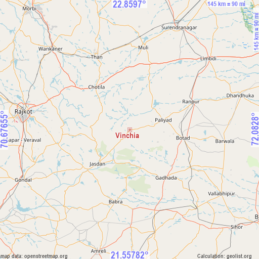
Vinchia GPS coordinates[2]
22° 12' 36.972" North, 71° 22' 46.812" East
| Map corner | latitude | longitude |
|---|---|---|
| Upper-left | 22.8597°, | 70.67655° |
| Center: | 22.21027°, | 71.37967° |
| Lower-right: | 21.55782°, | 72.0828° |
| Map W x H: | 144.8×144.8 km | = 90×90mi |
| max Lat: | 34.9274° ⇑55.1% North |
| Vinchia: | 22.21027° |
| min Lat: | ⇓44.9% South 8.09008° |
| min Long | Vinchia | max Long |
| 68.82655° | 71.37967° | 96.81° |
| W 1.8%⇐ | ⇒98.2% E |
Elevation
Elevation of Vinchia is 175 m = 574 ft, and this is 120.6 m = 396 ft below average elevation for this country.
| Max E: |
3681 m = 12077 ft | 55% |
| Avg. | 295.6 m = 970 ft | |
| Vinchia | 175 m = 574 ft | |
Min E: |
1 m = 3 ft | 45% |
See also: India elevation on elevation.city.
Geographical zone
Vinchia is located in North Torrid zone (between Equator and Tropic of Cancer). Distance of this Northern Tropic circle is 136.4 km =84.8 mi to North.| Distance of | km | miles | from Vinchia |
|---|---|---|---|
| North Pole | 7537.5 | 4683.6 | to North |
| Arctic Circle | 4931.6 | 3064.4 | to North |
| Tropic Cancer | 136.4 | 84.8 | to North |
| Equator | 2469.6 | 1534.5 | to South |


Nearby cities:
15 places around Vinchia: (largest is in red/bold)
• Botād
29.9 km =18.6 mi,  98°
98°
• Bābra
41.2 km =25.6 mi,  190°
190°
• Chotila
30.3 km =18.8 mi,  321°
321°
• Dhola
54.6 km =33.9 mi,  132°
132°
• Dāmnagar
59.3 km =36.8 mi,  166°
166°
• Gadhada
33.7 km =20.9 mi,  142°
142°
• Jasdan
26.1 km =16.2 mi,  222°
222°
• Limbdi
59.3 km =36.8 mi,  48°
48°
• Lāthi
54.2 km =33.7 mi,  179°
179°
• Pāliyād
19.3 km =12 mi,  74°
74°
• Rājkot
61 km =37.9 mi,  278°
278°
• Sāyla
39.2 km =24.4 mi,  15°
15°
• Thān
44.5 km =27.7 mi,  335°
335°
• Umrāla
59.7 km =37.1 mi, 133°
• Valabhīpur
62.7 km =39 mi,  124°
124°
Sources, notices
• [Note1] Compared only with cities in India existing in our database
• [Src1] Map data: © OpenStreetMap contributors (CC-BY-SA)
• [Src2] Other city data from geonames.org with taken over terms of usage.
• [Src3] Geographical zone / Annual Mean Temperature by Robert A. Rohde @ Wikipedia
