Tankāra geodata
Tankāra (Gujarat) is a populated place; located in India in Asia/Kolkata (GMT+5.5) time zone. With population of 10,175 people, there are 2927 cities with bigger population in this country. Compared to other cities in India, 51.5% of cities are located further ↑North; 98.8% of cities are located further →East and 75.9% of cities have higher elevation than Tankāra. Note1


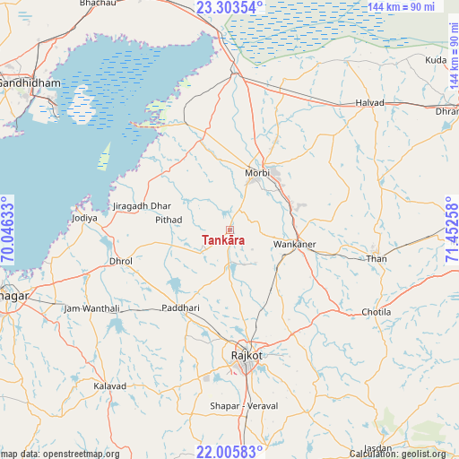
Tankāra GPS coordinates[2]
22° 39' 22.392" North, 70° 44' 58.02" East
| Map corner | latitude | longitude |
|---|---|---|
| Upper-left | 23.30354°, | 70.04633° |
| Center: | 22.65622°, | 70.74945° |
| Lower-right: | 22.00583°, | 71.45258° |
| Map W x H: | 144.3×144.3 km | = 89.7×89.7mi |
| max Lat: | 34.9274° ⇑51.5% North |
| Tankāra: | 22.65622° |
| min Lat: | ⇓48.5% South 8.09008° |
| min Long | Tankāra | max Long |
| 68.82655° | 70.74945° | 96.81° |
| W 1.2%⇐ | ⇒98.8% E |
Elevation
Elevation of Tankāra is 64 m = 210 ft, and this is 231.6 m = 760 ft below average elevation for this country.
| Max E: |
3681 m = 12077 ft | 75.9% |
| Avg. | 295.6 m = 970 ft | |
| Tankāra | 64 m = 210 ft | |
Min E: |
1 m = 3 ft | 24.1% |
See also: India elevation on elevation.city.
Geographical zone
Tankāra is located in North Torrid zone (between Equator and Tropic of Cancer). Distance of this Northern Tropic circle is 86.8 km =53.9 mi to North.| Distance of | km | miles | from Tankāra |
|---|---|---|---|
| North Pole | 7487.9 | 4652.8 | to North |
| Arctic Circle | 4882 | 3033.5 | to North |
| Tropic Cancer | 86.8 | 53.9 | to North |
| Equator | 2519.1 | 1565.3 | to South |


Nearby cities:
15 places around Tankāra: (largest is in red/bold)
• Bedi
74.5 km =46.3 mi,  256°
256°
• Chotila
52.7 km =32.7 mi,  119°
119°
• Dhrol
35.5 km =22.1 mi,  253°
253°
• Halvad
59.5 km =37 mi,  47°
47°
• Jamnagar
73 km =45.4 mi, 253°
• Jodiya Bandar
48.3 km =30 mi,  278°
278°
• Kālāvad
62.5 km =38.8 mi,  217°
217°
• Kāndla
68.8 km =42.8 mi,  307°
307°
• Morbi
20.1 km =12.5 mi,  26°
26°
• Paddhari
28.8 km =17.9 mi,  211°
211°
• Rājkot
40.8 km =25.4 mi,  173°
173°
• Shāhpur
55.6 km =34.5 mi,  177°
177°
• Sāyla
76.3 km =47.4 mi,  98°
98°
• Thān
47.1 km =29.3 mi, 101°
• Wānkāner
20.5 km =12.7 mi, 103°
Sources, notices
• [Note1] Compared only with cities in India existing in our database
• [Src1] Map data: © OpenStreetMap contributors (CC-BY-SA)
• [Src2] Other city data from geonames.org with taken over terms of usage.
• [Src3] Geographical zone / Annual Mean Temperature by Robert A. Rohde @ Wikipedia
