Thān geodata
Thān (Gujarat) is a populated place; located in India in Asia/Kolkata (GMT+5.5) time zone. With population of 42,508 people, there are 1039 cities with bigger population in this country. Compared to other cities in India, 52.5% of cities are located further ↑North; 98.3% of cities are located further →East and 60.8% of cities have higher elevation than Thān. Note1


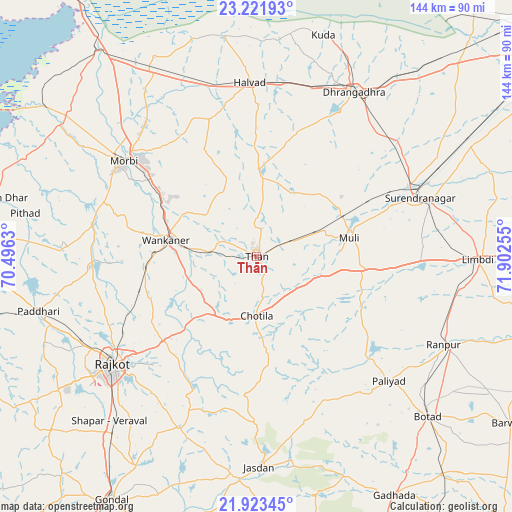
Thān GPS coordinates[2]
22° 34' 27.192" North, 71° 11' 57.912" East
| Map corner | latitude | longitude |
|---|---|---|
| Upper-left | 23.22193°, | 70.4963° |
| Center: | 22.57422°, | 71.19942° |
| Lower-right: | 21.92345°, | 71.90255° |
| Map W x H: | 144.4×144.4 km | = 89.7×89.7mi |
| max Lat: | 34.9274° ⇑52.5% North |
| Thān: | 22.57422° |
| min Lat: | ⇓47.5% South 8.09008° |
| min Long | Thān | max Long |
| 68.82655° | 71.19942° | 96.81° |
| W 1.7%⇐ | ⇒98.3% E |
Elevation
Elevation of Thān is 144 m = 472 ft, and this is 151.6 m = 497 ft below average elevation for this country.
| Max E: |
3681 m = 12077 ft | 60.8% |
| Avg. | 295.6 m = 970 ft | |
| Thān | 144 m = 472 ft | |
Min E: |
1 m = 3 ft | 39.2% |
See also: Thān elevation on elevation.city.
Geographical zone
Thān is located in North Torrid zone (between Equator and Tropic of Cancer). Distance of this Northern Tropic circle is 95.9 km =59.6 mi to North.| Distance of | km | miles | from Thān |
|---|---|---|---|
| North Pole | 7497 | 4658.4 | to North |
| Arctic Circle | 4891.2 | 3039.2 | to North |
| Tropic Cancer | 95.9 | 59.6 | to North |
| Equator | 2510 | 1559.6 | to South |


Nearby cities:
15 places around Thān: (largest is in red/bold)
• Chotila
16.8 km =10.4 mi,  181°
181°
• Dhrāngadhra
54 km =33.6 mi,  30°
30°
• Halvad
49.1 km =30.5 mi,  357°
357°
• Jasdan
59.7 km =37.1 mi, 179°
• Limbdi
62.8 km =39 mi,  90°
90°
• Morbi
45.9 km =28.5 mi,  306°
306°
• Paddhari
63.3 km =39.3 mi,  256°
256°
• Pāliyād
51.1 km =31.8 mi,  133°
133°
• Rājkot
52.3 km =32.5 mi,  233°
233°
• Shāhpur
64.1 km =39.8 mi,  223°
223°
• Surendranagar
49.1 km =30.5 mi,  69°
69°
• Sāyla
29.3 km =18.2 mi,  95°
95°
• Tankāra
47.1 km =29.3 mi,  281°
281°
• Vinchia
44.5 km =27.7 mi,  155°
155°
• Wānkāner
26.6 km =16.5 mi, 279°
Sources, notices
• [Note1] Compared only with cities in India existing in our database
• [Src1] Map data: © OpenStreetMap contributors (CC-BY-SA)
• [Src2] Other city data from geonames.org with taken over terms of usage.
• [Src3] Geographical zone / Annual Mean Temperature by Robert A. Rohde @ Wikipedia
