Annur geodata
Annur (Tamil Nadu) is a populated place; located in India in Asia/Kolkata (GMT+5.5) time zone. With population of 19,962 people, there are 2046 cities with bigger population in this country. Compared to other cities in India, 92.3% of cities are located further ↑North; 62% of cities are located further →East and 74.4% of cities have lower elevation than Annur. Note1


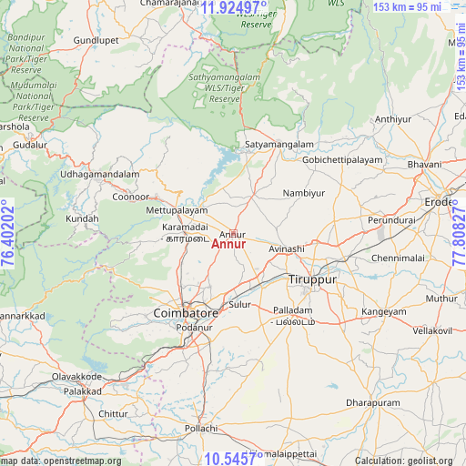
Annur GPS coordinates[2]
11° 14' 10.176" North, 77° 6' 18.504" East
| Map corner | latitude | longitude |
|---|---|---|
| Upper-left | 11.92497°, | 76.40202° |
| Center: | 11.23616°, | 77.10514° |
| Lower-right: | 10.5457°, | 77.80827° |
| Map W x H: | 153.4×153.4 km | = 95.3×95.3mi |
| max Lat: | 34.9274° ⇑92.3% North |
| Annur: | 11.23616° |
| min Lat: | ⇓7.7% South 8.09008° |
| min Long | Annur | max Long |
| 68.82655° | 77.10514° | 96.81° |
| W 38%⇐ | ⇒62% E |
Elevation
Elevation of Annur is 378 m = 1240 ft, and this is 82.4 m = 270 ft above average elevation for this country.
| Max E: |
3681 m = 12077 ft | 25.6% |
| Annur | 378 m 1240 ft | |
| Avg. | 295.6 m = 970 ft | |
Min E: |
1 m = 3 ft | 74.4% |
See also: India elevation on elevation.city.
Geographical zone
Annur is located in North Torrid zone (between Equator and Tropic of Cancer). Distance of Equator is 1249.3 km =776.3 mi to South.| Distance of | km | miles | from Annur |
|---|---|---|---|
| North Pole | 8757.7 | 5441.8 | to North |
| Arctic Circle | 6151.8 | 3822.6 | to North |
| Tropic Cancer | 1356.6 | 843 | to North |
| Equator | 1249.3 | 776.3 | to South |


Nearby cities:
15 places around Annur: (largest is in red/bold)
• Avinashi
18.5 km =11.5 mi,  105°
105°
• Coimbatore
29.8 km =18.5 mi,  210°
210°
• Irugūr
24.7 km =15.3 mi,  190°
190°
• Kotagiri
33.7 km =20.9 mi,  307°
307°
• Kāramadai
15.8 km =9.8 mi,  271°
271°
• Mettupalayam
19.9 km =12.4 mi,  290°
290°
• Nambiyūr
27.2 km =16.9 mi,  60°
60°
• Palladam
33.6 km =20.9 mi,  143°
143°
• Periyanayakkanpalaiyam
19.2 km =11.9 mi,  240°
240°
• Punjai Puliyampatti
14.5 km =9 mi,  27°
27°
• Sathyamangalam
33.3 km =20.7 mi, 25°
• Singānallūr
27.5 km =17.1 mi,  196°
196°
• Sirumugai
14.4 km =8.9 mi, 311°
• Sulur
23.7 km =14.7 mi,  174°
174°
• Tiruppur
30.3 km =18.8 mi,  116°
116°
Sources, notices
• [Note1] Compared only with cities in India existing in our database
• [Src1] Map data: © OpenStreetMap contributors (CC-BY-SA)
• [Src2] Other city data from geonames.org with taken over terms of usage.
• [Src3] Geographical zone / Annual Mean Temperature by Robert A. Rohde @ Wikipedia
