Sirumugai geodata
Sirumugai (Tamil Nadu) is a populated place; located in India in Asia/Kolkata (GMT+5.5) time zone. With population of 20,066 people, there are 2040 cities with bigger population in this country. Compared to other cities in India, 92% of cities are located further ↑North; 63.1% of cities are located further →East and 65.4% of cities have lower elevation than Sirumugai. Note1


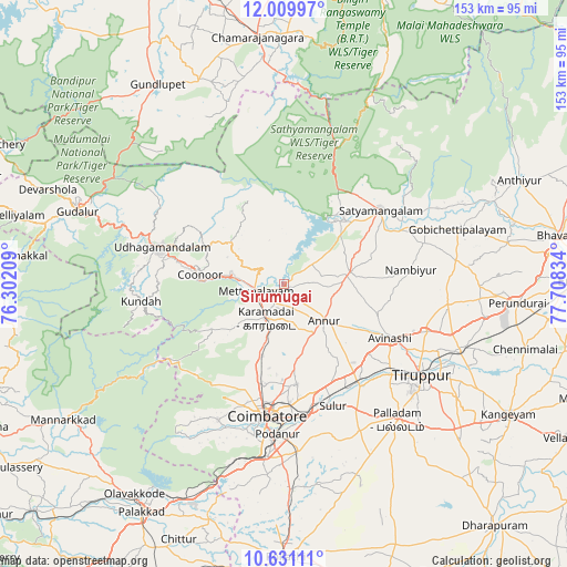
Sirumugai GPS coordinates[2]
11° 19' 16.932" North, 77° 0' 18.756" East
| Map corner | latitude | longitude |
|---|---|---|
| Upper-left | 12.00997°, | 76.30209° |
| Center: | 11.32137°, | 77.00521° |
| Lower-right: | 10.63111°, | 77.70834° |
| Map W x H: | 153.3×153.3 km | = 95.3×95.3mi |
| max Lat: | 34.9274° ⇑92% North |
| Sirumugai: | 11.32137° |
| min Lat: | ⇓8% South 8.09008° |
| min Long | Sirumugai | max Long |
| 68.82655° | 77.00521° | 96.81° |
| W 36.9%⇐ | ⇒63.1% E |
Elevation
Elevation of Sirumugai is 288 m = 945 ft, and this is 7.6 m = 25 ft below average elevation for this country.
| Max E: |
3681 m = 12077 ft | 34.6% |
| Avg. | 295.6 m = 970 ft | |
| Sirumugai | 288 m = 945 ft | |
Min E: |
1 m = 3 ft | 65.4% |
See also: India elevation on elevation.city.
Geographical zone
Sirumugai is located in North Torrid zone (between Equator and Tropic of Cancer). Distance of Equator is 1258.8 km =782.2 mi to South.| Distance of | km | miles | from Sirumugai |
|---|---|---|---|
| North Pole | 8748.2 | 5435.9 | to North |
| Arctic Circle | 6142.4 | 3816.7 | to North |
| Tropic Cancer | 1347.1 | 837 | to North |
| Equator | 1258.8 | 782.2 | to South |


Nearby cities:
15 places around Sirumugai: (largest is in red/bold)
• Annur
14.4 km =8.9 mi,  131°
131°
• Aruvankad
27.4 km =17 mi,  279°
279°
• Avinashi
32.1 km =19.9 mi,  116°
116°
• Coimbatore
35.4 km =22 mi,  186°
186°
• Irugūr
34.3 km =21.3 mi,  169°
169°
• Kotagiri
19.3 km =12 mi,  304°
304°
• Kāramadai
10.2 km =6.3 mi,  208°
208°
• Mettupalayam
8 km =5 mi,  252°
252°
• Nambiyūr
34.7 km =21.6 mi,  83°
83°
• Ooty
35.3 km =21.9 mi,  286°
286°
• Periyanayakkanpalaiyam
19.7 km =12.2 mi,  197°
197°
• Punjai Puliyampatti
17.9 km =11.1 mi, 79°
• Sathyamangalam
32.6 km =20.3 mi,  51°
51°
• Sulur
35.6 km =22.1 mi,  158°
158°
• Wellington
24.6 km =15.3 mi, 281°
Sources, notices
• [Note1] Compared only with cities in India existing in our database
• [Src1] Map data: © OpenStreetMap contributors (CC-BY-SA)
• [Src2] Other city data from geonames.org with taken over terms of usage.
• [Src3] Geographical zone / Annual Mean Temperature by Robert A. Rohde @ Wikipedia
