Kāramadai geodata
Kāramadai (Tamil Nadu) is a populated place; located in India in Asia/Kolkata (GMT+5.5) time zone. With population of 31,188 people, there are 1389 cities with bigger population in this country. Compared to other cities in India, 92.2% of cities are located further ↑North; 63.6% of cities are located further →East and 73.5% of cities have lower elevation than Kāramadai. Note1


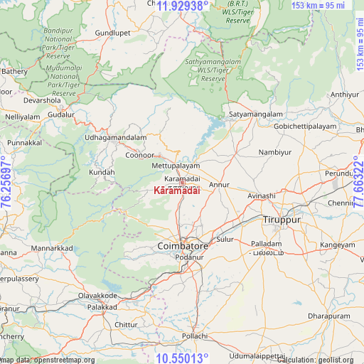
Kāramadai GPS coordinates[2]
11° 14' 26.088" North, 76° 57' 36.324" East
| Map corner | latitude | longitude |
|---|---|---|
| Upper-left | 11.92938°, | 76.25697° |
| Center: | 11.24058°, | 76.96009° |
| Lower-right: | 10.55013°, | 77.66322° |
| Map W x H: | 153.4×153.4 km | = 95.3×95.3mi |
| max Lat: | 34.9274° ⇑92.2% North |
| Kāramadai: | 11.24058° |
| min Lat: | ⇓7.8% South 8.09008° |
| min Long | Kāramadai | max Long |
| 68.82655° | 76.96009° | 96.81° |
| W 36.4%⇐ | ⇒63.6% E |
Elevation
Elevation of Kāramadai is 367 m = 1204 ft, and this is 71.4 m = 234 ft above average elevation for this country.
| Max E: |
3681 m = 12077 ft | 26.5% |
| Kāramadai | 367 m 1204 ft | |
| Avg. | 295.6 m = 970 ft | |
Min E: |
1 m = 3 ft | 73.5% |
See also: India elevation on elevation.city.
Geographical zone
Kāramadai is located in North Torrid zone (between Equator and Tropic of Cancer). Distance of Equator is 1249.8 km =776.6 mi to South.| Distance of | km | miles | from Kāramadai |
|---|---|---|---|
| North Pole | 8757.2 | 5441.5 | to North |
| Arctic Circle | 6151.3 | 3822.2 | to North |
| Tropic Cancer | 1356.1 | 842.6 | to North |
| Equator | 1249.8 | 776.6 | to South |


Nearby cities:
15 places around Kāramadai: (largest is in red/bold)
• Annur
15.8 km =9.8 mi,  91°
91°
• Aruvankad
25.9 km =16.1 mi,  301°
301°
• Avinashi
34.1 km =21.2 mi,  98°
98°
• Coimbatore
26.1 km =16.2 mi,  178°
178°
• Irugūr
27.2 km =16.9 mi,  155°
155°
• Kotagiri
22.8 km =14.2 mi,  331°
331°
• Mettupalayam
7.1 km =4.4 mi,  337°
337°
• Ooty
34.7 km =21.6 mi, 303°
• Periyanayakkanpalaiyam
9.8 km =6.1 mi,  185°
185°
• Perūr
30 km =18.6 mi, 189°
• Punjai Puliyampatti
25.7 km =16 mi,  61°
61°
• Singānallūr
28 km =17.4 mi, 163°
• Sirumugai
10.2 km =6.3 mi,  28°
28°
• Sulur
30.1 km =18.7 mi,  143°
143°
• Wellington
23.7 km =14.7 mi,  305°
305°
Sources, notices
• [Note1] Compared only with cities in India existing in our database
• [Src1] Map data: © OpenStreetMap contributors (CC-BY-SA)
• [Src2] Other city data from geonames.org with taken over terms of usage.
• [Src3] Geographical zone / Annual Mean Temperature by Robert A. Rohde @ Wikipedia
