Satwās geodata
Satwās (Madhya Pradesh) is a populated place; located in India in Asia/Kolkata (GMT+5.5) time zone. With population of 12,115 people, there are 2728 cities with bigger population in this country. Compared to other cities in India, 52.8% of cities are located further ↑North; 66.5% of cities are located further →East and 67.6% of cities have lower elevation than Satwās. Note1


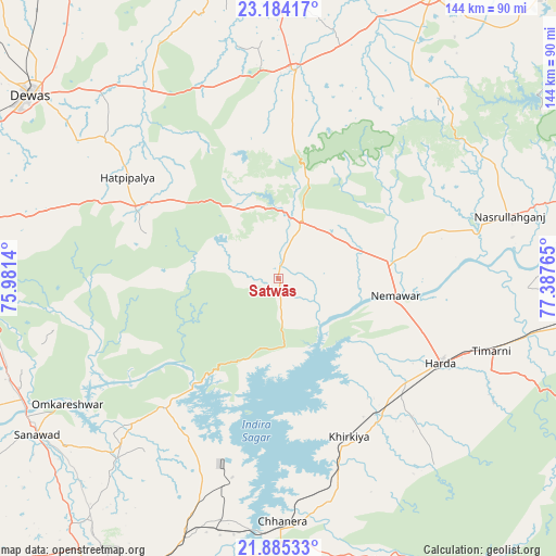
Satwās GPS coordinates[2]
22° 32' 10.608" North, 76° 41' 4.272" East
| Map corner | latitude | longitude |
|---|---|---|
| Upper-left | 23.18417°, | 75.9814° |
| Center: | 22.53628°, | 76.68452° |
| Lower-right: | 21.88533°, | 77.38765° |
| Map W x H: | 144.4×144.4 km | = 89.7×89.7mi |
| max Lat: | 34.9274° ⇑52.8% North |
| Satwās: | 22.53628° |
| min Lat: | ⇓47.2% South 8.09008° |
| min Long | Satwās | max Long |
| 68.82655° | 76.68452° | 96.81° |
| W 33.5%⇐ | ⇒66.5% E |
Elevation
Elevation of Satwās is 306 m = 1004 ft, and this is 10.4 m = 34 ft above average elevation for this country.
| Max E: |
3681 m = 12077 ft | 32.4% |
| Satwās | 306 m 1004 ft | |
| Avg. | 295.6 m = 970 ft | |
Min E: |
1 m = 3 ft | 67.6% |
See also: India elevation on elevation.city.
Geographical zone
Satwās is located in North Torrid zone (between Equator and Tropic of Cancer). Distance of this Northern Tropic circle is 100.1 km =62.2 mi to North.| Distance of | km | miles | from Satwās |
|---|---|---|---|
| North Pole | 7501.3 | 4661.1 | to North |
| Arctic Circle | 4895.4 | 3041.9 | to North |
| Tropic Cancer | 100.1 | 62.2 | to North |
| Equator | 2505.8 | 1557 | to South |


Nearby cities:
15 places around Satwās: (largest is in red/bold)
• Ashta
53.6 km =33.3 mi,  4°
4°
• Bāgli
36.4 km =22.6 mi,  288°
288°
• Harda Khās
47.3 km =29.4 mi,  116°
116°
• Harsūd
48.8 km =30.3 mi,  173°
173°
• Ichhāwar
64.5 km =40.1 mi,  31°
31°
• Iklehra
74.3 km =46.2 mi,  336°
336°
• Iāwar
55.9 km =34.7 mi, 340°
• Kannod
15.8 km =9.8 mi,  22°
22°
• Khirkiyān
44.9 km =27.9 mi,  156°
156°
• Khātegaon
24.4 km =15.2 mi,  74°
74°
• Mundi
55.8 km =34.7 mi,  200°
200°
• Nasrullāhganj
62.4 km =38.8 mi, 74°
• Punāsa
44.9 km =27.9 mi,  221°
221°
• Rehti
80.1 km =49.8 mi, 73°
• Sanāwad
75 km =46.6 mi,  237°
237°
Sources, notices
• [Note1] Compared only with cities in India existing in our database
• [Src1] Map data: © OpenStreetMap contributors (CC-BY-SA)
• [Src2] Other city data from geonames.org with taken over terms of usage.
• [Src3] Geographical zone / Annual Mean Temperature by Robert A. Rohde @ Wikipedia
