Ashta geodata
Ashta (Madhya Pradesh) is a populated place; located in India in Asia/Kolkata (GMT+5.5) time zone. With population of 45,365 people, there are 977 cities with bigger population in this country. Compared to other cities in India, 51.8% of cities are located further ↓South; 66.1% of cities are located further →East and 82.3% of cities have lower elevation than Ashta. Note1


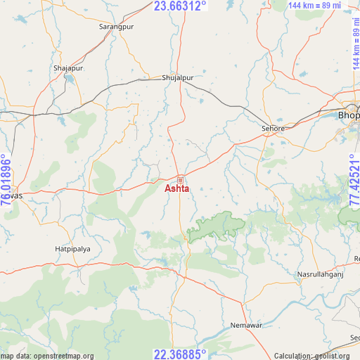
Ashta GPS coordinates[2]
23° 1' 3.144" North, 76° 43' 19.488" East
| Map corner | latitude | longitude |
|---|---|---|
| Upper-left | 23.66312°, | 76.01896° |
| Center: | 23.01754°, | 76.72208° |
| Lower-right: | 22.36885°, | 77.42521° |
| Map W x H: | 143.9×143.9 km | = 89.4×89.4mi |
| max Lat: | 34.9274° ⇑48.2% North |
| Ashta: | 23.01754° |
| min Lat: | ⇓51.8% South 8.09008° |
| min Long | Ashta | max Long |
| 68.82655° | 76.72208° | 96.81° |
| W 33.9%⇐ | ⇒66.1% E |
Elevation
Elevation of Ashta is 498 m = 1634 ft, and this is 202.4 m = 664 ft above average elevation for this country.
| Max E: |
3681 m = 12077 ft | 17.7% |
| Ashta | 498 m 1634 ft | |
| Avg. | 295.6 m = 970 ft | |
Min E: |
1 m = 3 ft | 82.3% |
See also: Ashta elevation on elevation.city.
Geographical zone
Ashta is located in North Torrid zone (between Equator and Tropic of Cancer). Distance of this Northern Tropic circle is 46.6 km =29 mi to North.| Distance of | km | miles | from Ashta |
|---|---|---|---|
| North Pole | 7447.8 | 4627.8 | to North |
| Arctic Circle | 4841.9 | 3008.6 | to North |
| Tropic Cancer | 46.6 | 29 | to North |
| Equator | 2559.3 | 1590.3 | to South |


Nearby cities:
15 places around Ashta: (largest is in red/bold)
• Akodia
42.3 km =26.3 mi,  342°
342°
• Bāgli
56.7 km =35.2 mi,  222°
222°
• Ichhāwar
30.2 km =18.8 mi,  87°
87°
• Iklehra
36.8 km =22.9 mi,  292°
292°
• Iāwar
22.7 km =14.1 mi,  267°
267°
• Kannod
39 km =24.2 mi,  176°
176°
• Khātegaon
50.8 km =31.6 mi,  157°
157°
• Maksi
64.8 km =40.3 mi, 294°
• Nasrullāhganj
67.4 km =41.9 mi,  123°
123°
• Satwās
53.6 km =33.3 mi, 184°
• Sehore
42.1 km =26.2 mi,  61°
61°
• Shujālpur
43.3 km =26.9 mi,  358°
358°
• Shājāpur
64.2 km =39.9 mi,  315°
315°
• Sārangpur
66.1 km =41.1 mi, 337°
• Talen
61.4 km =38.2 mi,  0°
0°
Sources, notices
• [Note1] Compared only with cities in India existing in our database
• [Src1] Map data: © OpenStreetMap contributors (CC-BY-SA)
• [Src2] Other city data from geonames.org with taken over terms of usage.
• [Src3] Geographical zone / Annual Mean Temperature by Robert A. Rohde @ Wikipedia
