Nasrullāhganj geodata
Nasrullāhganj (Madhya Pradesh) is a populated place; located in India in Asia/Kolkata (GMT+5.5) time zone. With population of 18,265 people, there are 2182 cities with bigger population in this country. Compared to other cities in India, 51.2% of cities are located further ↑North; 60.3% of cities are located further →East and 67% of cities have lower elevation than Nasrullāhganj. Note1


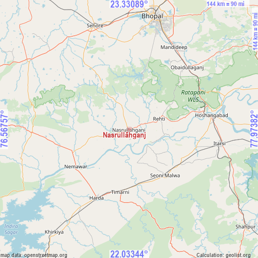
Nasrullāhganj GPS coordinates[2]
22° 41' 1.32" North, 77° 16' 14.484" East
| Map corner | latitude | longitude |
|---|---|---|
| Upper-left | 23.33089°, | 76.56757° |
| Center: | 22.6837°, | 77.27069° |
| Lower-right: | 22.03344°, | 77.97382° |
| Map W x H: | 144.3×144.3 km | = 89.7×89.7mi |
| max Lat: | 34.9274° ⇑51.2% North |
| Nasrullāhganj: | 22.6837° |
| min Lat: | ⇓48.8% South 8.09008° |
| min Long | Nasrullāhganj | max Long |
| 68.82655° | 77.27069° | 96.81° |
| W 39.7%⇐ | ⇒60.3% E |
Elevation
Elevation of Nasrullāhganj is 301 m = 988 ft, and this is 5.4 m = 18 ft above average elevation for this country.
| Max E: |
3681 m = 12077 ft | 33% |
| Nasrullāhganj | 301 m 988 ft | |
| Avg. | 295.6 m = 970 ft | |
Min E: |
1 m = 3 ft | 67% |
See also: India elevation on elevation.city.
Geographical zone
Nasrullāhganj is located in North Torrid zone (between Equator and Tropic of Cancer). Distance of this Northern Tropic circle is 83.7 km =52 mi to North.| Distance of | km | miles | from Nasrullāhganj |
|---|---|---|---|
| North Pole | 7484.9 | 4650.9 | to North |
| Arctic Circle | 4879 | 3031.7 | to North |
| Tropic Cancer | 83.7 | 52 | to North |
| Equator | 2522.2 | 1567.2 | to South |


Nearby cities:
15 places around Nasrullāhganj: (largest is in red/bold)
• Ashta
67.4 km =41.9 mi,  303°
303°
• Bhopal
64.9 km =40.3 mi,  12°
12°
• Bābai
68.2 km =42.4 mi,  88°
88°
• Harda Khās
41.8 km =26 mi,  205°
205°
• Hoshangābād
47.4 km =29.5 mi,  81°
81°
• Ichhāwar
46.3 km =28.8 mi,  325°
325°
• Itārsi
51 km =31.7 mi,  98°
98°
• Kannod
54.2 km =33.7 mi,  268°
268°
• Khirkiyān
71.2 km =44.2 mi,  216°
216°
• Khātegaon
38 km =23.6 mi,  255°
255°
• Mandideep
51.8 km =32.2 mi,  31°
31°
• Rehti
17.8 km =11.1 mi,  70°
70°
• Satwās
62.4 km =38.8 mi,  254°
254°
• Sehore
60.5 km =37.6 mi,  341°
341°
• Seoni Mālwa
32.8 km =20.4 mi,  142°
142°
Sources, notices
• [Note1] Compared only with cities in India existing in our database
• [Src1] Map data: © OpenStreetMap contributors (CC-BY-SA)
• [Src2] Other city data from geonames.org with taken over terms of usage.
• [Src3] Geographical zone / Annual Mean Temperature by Robert A. Rohde @ Wikipedia
