Punāsa geodata
Punāsa (Madhya Pradesh) is a populated place; located in India in Asia/Kolkata (GMT+5.5) time zone. With population of 350,000 people, there are 121 cities with bigger population in this country. Compared to other cities in India, 54.9% of cities are located further ↑North; 69.3% of cities are located further →East and 63.9% of cities have lower elevation than Punāsa. Note1


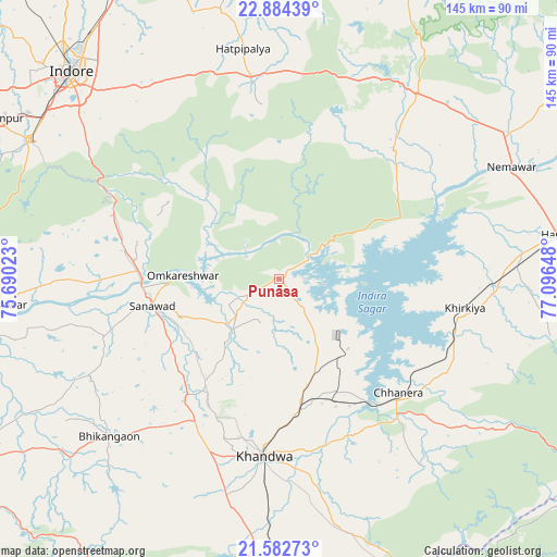
Punāsa GPS coordinates[2]
22° 14' 6.252" North, 76° 23' 36.06" East
| Map corner | latitude | longitude |
|---|---|---|
| Upper-left | 22.88439°, | 75.69023° |
| Center: | 22.23507°, | 76.39335° |
| Lower-right: | 21.58273°, | 77.09648° |
| Map W x H: | 144.7×144.7 km | = 89.9×89.9mi |
| max Lat: | 34.9274° ⇑54.9% North |
| Punāsa: | 22.23507° |
| min Lat: | ⇓45.1% South 8.09008° |
| min Long | Punāsa | max Long |
| 68.82655° | 76.39335° | 96.81° |
| W 30.7%⇐ | ⇒69.3% E |
Elevation
Elevation of Punāsa is 278 m = 912 ft, and this is 17.6 m = 58 ft below average elevation for this country.
| Max E: |
3681 m = 12077 ft | 36.1% |
| Avg. | 295.6 m = 970 ft | |
| Punāsa | 278 m = 912 ft | |
Min E: |
1 m = 3 ft | 63.9% |
See also: Punāsa elevation on elevation.city.
Geographical zone
Punāsa is located in North Torrid zone (between Equator and Tropic of Cancer). Distance of this Northern Tropic circle is 133.6 km =83 mi to North.| Distance of | km | miles | from Punāsa |
|---|---|---|---|
| North Pole | 7534.8 | 4681.9 | to North |
| Arctic Circle | 4928.9 | 3062.7 | to North |
| Tropic Cancer | 133.6 | 83 | to North |
| Equator | 2472.3 | 1536.2 | to South |


Nearby cities:
15 places around Punāsa: (largest is in red/bold)
• Bhikangaon
60.2 km =37.4 mi,  227°
227°
• Bāgli
45.4 km =28.2 mi,  354°
354°
• Harda Khās
73.2 km =45.5 mi,  80°
80°
• Harsūd
38.2 km =23.7 mi,  113°
113°
• Indore
78.7 km =48.9 mi,  313°
313°
• Kannod
60 km =37.3 mi,  36°
36°
• Kasrāwad
81.4 km =50.6 mi,  261°
261°
• Khandwa
45.9 km =28.5 mi,  185°
185°
• Khirkiyān
48.8 km =30.3 mi,  98°
98°
• Khātegaon
66.8 km =41.5 mi,  53°
53°
• Mundi
21.3 km =13.2 mi,  151°
151°
• Māndleshwar
75.8 km =47.1 mi,  265°
265°
• Pandhāna
62.2 km =38.6 mi,  196°
196°
• Sanāwad
34 km =21.1 mi, 258°
• Satwās
44.9 km =27.9 mi, 41°
Sources, notices
• [Note1] Compared only with cities in India existing in our database
• [Src1] Map data: © OpenStreetMap contributors (CC-BY-SA)
• [Src2] Other city data from geonames.org with taken over terms of usage.
• [Src3] Geographical zone / Annual Mean Temperature by Robert A. Rohde @ Wikipedia
