Bāgli geodata
Bāgli (Madhya Pradesh) is a populated place; located in India in Asia/Kolkata (GMT+5.5) time zone. With population of 10,764 people, there are 2861 cities with bigger population in this country. Compared to other cities in India, 51.7% of cities are located further ↑North; 69.8% of cities are located further →East and 85.2% of cities have lower elevation than Bāgli. Note1


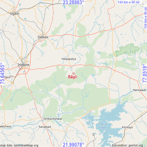
Bāgli GPS coordinates[2]
22° 38' 28.464" North, 76° 20' 55.572" East
| Map corner | latitude | longitude |
|---|---|---|
| Upper-left | 23.28863°, | 75.64565° |
| Center: | 22.64124°, | 76.34877° |
| Lower-right: | 21.99078°, | 77.0519° |
| Map W x H: | 144.3×144.3 km | = 89.7×89.7mi |
| max Lat: | 34.9274° ⇑51.7% North |
| Bāgli: | 22.64124° |
| min Lat: | ⇓48.3% South 8.09008° |
| min Long | Bāgli | max Long |
| 68.82655° | 76.34877° | 96.81° |
| W 30.2%⇐ | ⇒69.8% E |
Elevation
Elevation of Bāgli is 553 m = 1814 ft, and this is 257.4 m = 844 ft above average elevation for this country.
| Max E: |
3681 m = 12077 ft | 14.8% |
| Bāgli | 553 m 1814 ft | |
| Avg. | 295.6 m = 970 ft | |
Min E: |
1 m = 3 ft | 85.2% |
See also: India elevation on elevation.city.
Geographical zone
Bāgli is located in North Torrid zone (between Equator and Tropic of Cancer). Distance of this Northern Tropic circle is 88.4 km =54.9 mi to North.| Distance of | km | miles | from Bāgli |
|---|---|---|---|
| North Pole | 7489.6 | 4653.8 | to North |
| Arctic Circle | 4883.7 | 3034.6 | to North |
| Tropic Cancer | 88.4 | 54.9 | to North |
| Equator | 2517.5 | 1564.3 | to South |


Nearby cities:
15 places around Bāgli: (largest is in red/bold)
• Ashta
56.7 km =35.2 mi,  42°
42°
• Dewas
47 km =29.2 mi,  320°
320°
• Hātod
64.8 km =40.3 mi,  285°
285°
• Iklehra
56.4 km =35 mi,  4°
4°
• Indore
53.6 km =33.3 mi,  279°
279°
• Iāwar
43.8 km =27.2 mi,  20°
20°
• Kannod
40.5 km =25.2 mi,  85°
85°
• Khātegaon
58.2 km =36.2 mi, 94°
• Maksi
71.9 km =44.7 mi,  343°
343°
• Mundi
65.6 km =40.8 mi,  166°
166°
• Pithampur
67.1 km =41.7 mi,  266°
266°
• Punāsa
45.4 km =28.2 mi, 174°
• Sanāwad
59.3 km =36.8 mi,  208°
208°
• Satwās
36.4 km =22.6 mi,  108°
108°
• Sānwer
65 km =40.4 mi,  304°
304°
Sources, notices
• [Note1] Compared only with cities in India existing in our database
• [Src1] Map data: © OpenStreetMap contributors (CC-BY-SA)
• [Src2] Other city data from geonames.org with taken over terms of usage.
• [Src3] Geographical zone / Annual Mean Temperature by Robert A. Rohde @ Wikipedia
