Khirkiyān geodata
Khirkiyān (Madhya Pradesh) is a populated place; located in India in Asia/Kolkata (GMT+5.5) time zone. With population of 18,498 people, there are 2165 cities with bigger population in this country. Compared to other cities in India, 55.7% of cities are located further ↑North; 64.6% of cities are located further →East and 64.2% of cities have lower elevation than Khirkiyān. Note1


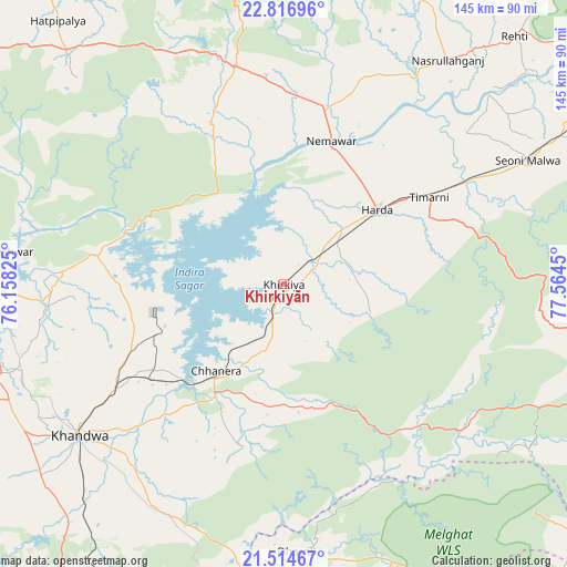
Khirkiyān GPS coordinates[2]
22° 10' 2.352" North, 76° 51' 40.932" East
| Map corner | latitude | longitude |
|---|---|---|
| Upper-left | 22.81696°, | 76.15825° |
| Center: | 22.16732°, | 76.86137° |
| Lower-right: | 21.51467°, | 77.5645° |
| Map W x H: | 144.8×144.8 km | = 90×90mi |
| max Lat: | 34.9274° ⇑55.7% North |
| Khirkiyān: | 22.16732° |
| min Lat: | ⇓44.3% South 8.09008° |
| min Long | Khirkiyān | max Long |
| 68.82655° | 76.86137° | 96.81° |
| W 35.4%⇐ | ⇒64.6% E |
Elevation
Elevation of Khirkiyān is 280 m = 919 ft, and this is 15.6 m = 51 ft below average elevation for this country.
| Max E: |
3681 m = 12077 ft | 35.8% |
| Avg. | 295.6 m = 970 ft | |
| Khirkiyān | 280 m = 919 ft | |
Min E: |
1 m = 3 ft | 64.2% |
See also: India elevation on elevation.city.
Geographical zone
Khirkiyān is located in North Torrid zone (between Equator and Tropic of Cancer). Distance of this Northern Tropic circle is 141.1 km =87.7 mi to North.| Distance of | km | miles | from Khirkiyān |
|---|---|---|---|
| North Pole | 7542.3 | 4686.6 | to North |
| Arctic Circle | 4936.4 | 3067.3 | to North |
| Tropic Cancer | 141.1 | 87.7 | to North |
| Equator | 2464.8 | 1531.6 | to South |


Nearby cities:
15 places around Khirkiyān: (largest is in red/bold)
• Bāgli
74.5 km =46.3 mi,  315°
315°
• Harda Khās
31.1 km =19.3 mi,  50°
50°
• Harsūd
15.1 km =9.4 mi,  240°
240°
• Kannod
56.9 km =35.4 mi,  347°
347°
• Khandwa
65 km =40.4 mi,  234°
234°
• Khātegaon
47.9 km =29.8 mi,  6°
6°
• Mundi
39.5 km =24.5 mi,  253°
253°
• Nasrullāhganj
71.2 km =44.2 mi,  36°
36°
• Nepānagar
92.9 km =57.7 mi,  211°
211°
• Pandhāna
83.9 km =52.1 mi, 231°
• Punāsa
48.8 km =30.3 mi,  278°
278°
• Rehti
86.5 km =53.7 mi, 42°
• Sanāwad
81.5 km =50.6 mi,  270°
270°
• Satwās
44.9 km =27.9 mi,  336°
336°
• Seoni Mālwa
69.8 km =43.4 mi,  63°
63°
Sources, notices
• [Note1] Compared only with cities in India existing in our database
• [Src1] Map data: © OpenStreetMap contributors (CC-BY-SA)
• [Src2] Other city data from geonames.org with taken over terms of usage.
• [Src3] Geographical zone / Annual Mean Temperature by Robert A. Rohde @ Wikipedia
