Kannod geodata
Kannod (Madhya Pradesh) is a populated place; located in India in Asia/Kolkata (GMT+5.5) time zone. With population of 15,870 people, there are 2379 cities with bigger population in this country. Compared to other cities in India, 51.4% of cities are located further ↑North; 65.8% of cities are located further →East and 70.5% of cities have lower elevation than Kannod. Note1


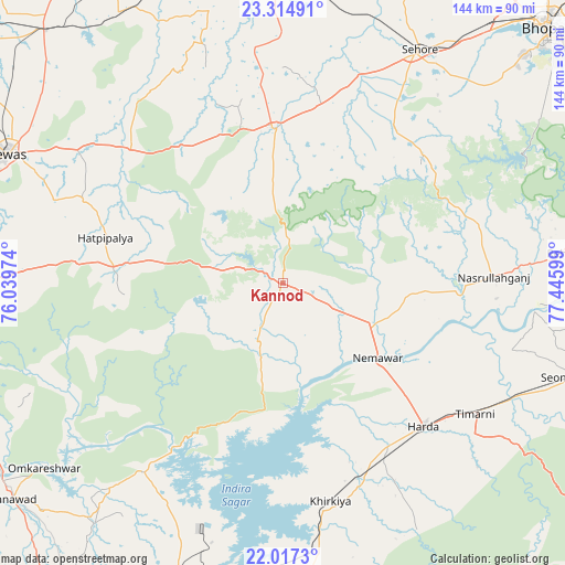
Kannod GPS coordinates[2]
22° 40' 3.504" North, 76° 44' 34.296" East
| Map corner | latitude | longitude |
|---|---|---|
| Upper-left | 23.31491°, | 76.03974° |
| Center: | 22.66764°, | 76.74286° |
| Lower-right: | 22.0173°, | 77.44599° |
| Map W x H: | 144.3×144.3 km | = 89.7×89.7mi |
| max Lat: | 34.9274° ⇑51.4% North |
| Kannod: | 22.66764° |
| min Lat: | ⇓48.6% South 8.09008° |
| min Long | Kannod | max Long |
| 68.82655° | 76.74286° | 96.81° |
| W 34.2%⇐ | ⇒65.8% E |
Elevation
Elevation of Kannod is 332 m = 1089 ft, and this is 36.4 m = 119 ft above average elevation for this country.
| Max E: |
3681 m = 12077 ft | 29.5% |
| Kannod | 332 m 1089 ft | |
| Avg. | 295.6 m = 970 ft | |
Min E: |
1 m = 3 ft | 70.5% |
See also: India elevation on elevation.city.
Geographical zone
Kannod is located in North Torrid zone (between Equator and Tropic of Cancer). Distance of this Northern Tropic circle is 85.5 km =53.1 mi to North.| Distance of | km | miles | from Kannod |
|---|---|---|---|
| North Pole | 7486.7 | 4652 | to North |
| Arctic Circle | 4880.8 | 3032.8 | to North |
| Tropic Cancer | 85.5 | 53.1 | to North |
| Equator | 2520.4 | 1566.1 | to South |


Nearby cities:
15 places around Kannod: (largest is in red/bold)
• Ashta
39 km =24.2 mi,  356°
356°
• Bāgli
40.5 km =25.2 mi,  265°
265°
• Harda Khās
51 km =31.7 mi,  134°
134°
• Harsūd
63.2 km =39.3 mi,  180°
180°
• Ichhāwar
49 km =30.4 mi,  35°
35°
• Iklehra
64.3 km =40 mi,  325°
325°
• Iāwar
45.4 km =28.2 mi, 326°
• Khirkiyān
56.9 km =35.4 mi,  167°
167°
• Khātegaon
19.2 km =11.9 mi,  114°
114°
• Mundi
71.6 km =44.5 mi,  201°
201°
• Nasrullāhganj
54.2 km =33.7 mi,  88°
88°
• Punāsa
60 km =37.3 mi,  216°
216°
• Rehti
71.3 km =44.3 mi,  83°
83°
• Satwās
15.8 km =9.8 mi, 202°
• Sehore
68.7 km =42.7 mi,  30°
30°
Sources, notices
• [Note1] Compared only with cities in India existing in our database
• [Src1] Map data: © OpenStreetMap contributors (CC-BY-SA)
• [Src2] Other city data from geonames.org with taken over terms of usage.
• [Src3] Geographical zone / Annual Mean Temperature by Robert A. Rohde @ Wikipedia
