Khātegaon geodata
Khātegaon (Madhya Pradesh) is a populated place; located in India in Asia/Kolkata (GMT+5.5) time zone. With population of 23,405 people, there are 1809 cities with bigger population in this country. Compared to other cities in India, 52.2% of cities are located further ↑North; 64.2% of cities are located further →East and 67.1% of cities have lower elevation than Khātegaon. Note1


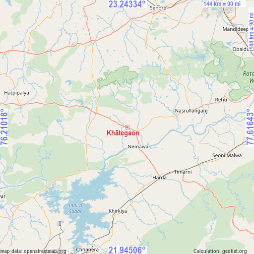
Khātegaon GPS coordinates[2]
22° 35' 44.628" North, 76° 54' 47.88" East
| Map corner | latitude | longitude |
|---|---|---|
| Upper-left | 23.24334°, | 76.21018° |
| Center: | 22.59573°, | 76.9133° |
| Lower-right: | 21.94506°, | 77.61643° |
| Map W x H: | 144.4×144.4 km | = 89.7×89.7mi |
| max Lat: | 34.9274° ⇑52.2% North |
| Khātegaon: | 22.59573° |
| min Lat: | ⇓47.8% South 8.09008° |
| min Long | Khātegaon | max Long |
| 68.82655° | 76.9133° | 96.81° |
| W 35.8%⇐ | ⇒64.2% E |
Elevation
Elevation of Khātegaon is 302 m = 991 ft, and this is 6.4 m = 21 ft above average elevation for this country.
| Max E: |
3681 m = 12077 ft | 32.9% |
| Khātegaon | 302 m 991 ft | |
| Avg. | 295.6 m = 970 ft | |
Min E: |
1 m = 3 ft | 67.1% |
See also: India elevation on elevation.city.
Geographical zone
Khātegaon is located in North Torrid zone (between Equator and Tropic of Cancer). Distance of this Northern Tropic circle is 93.5 km =58.1 mi to North.| Distance of | km | miles | from Khātegaon |
|---|---|---|---|
| North Pole | 7494.7 | 4657 | to North |
| Arctic Circle | 4888.8 | 3037.8 | to North |
| Tropic Cancer | 93.5 | 58.1 | to North |
| Equator | 2512.4 | 1561.1 | to South |


Nearby cities:
15 places around Khātegaon: (largest is in red/bold)
• Ashta
50.8 km =31.6 mi,  337°
337°
• Bāgli
58.2 km =36.2 mi,  274°
274°
• Harda Khās
33.7 km =20.9 mi,  146°
146°
• Harsūd
58.2 km =36.2 mi,  198°
198°
• Ichhāwar
49.2 km =30.6 mi,  12°
12°
• Iāwar
62.5 km =38.8 mi,  317°
317°
• Kannod
19.2 km =11.9 mi,  294°
294°
• Khirkiyān
47.9 km =29.8 mi,  186°
186°
• Mundi
73 km =45.4 mi,  216°
216°
• Nasrullāhganj
38 km =23.6 mi,  75°
75°
• Punāsa
66.8 km =41.5 mi,  233°
233°
• Rehti
55.7 km =34.6 mi,  73°
73°
• Satwās
24.4 km =15.2 mi,  254°
254°
• Sehore
69.4 km =43.1 mi, 14°
• Seoni Mālwa
59.1 km =36.7 mi,  105°
105°
Sources, notices
• [Note1] Compared only with cities in India existing in our database
• [Src1] Map data: © OpenStreetMap contributors (CC-BY-SA)
• [Src2] Other city data from geonames.org with taken over terms of usage.
• [Src3] Geographical zone / Annual Mean Temperature by Robert A. Rohde @ Wikipedia
