Shirwal geodata
Shirwal (Maharashtra) is a populated place; located in India in Asia/Kolkata (GMT+5.5) time zone. With population of 12,703 people, there are 2677 cities with bigger population in this country. Compared to other cities in India, 71.4% of cities are located further ↑North; 89.7% of cities are located further →East and 88.2% of cities have lower elevation than Shirwal. Note1


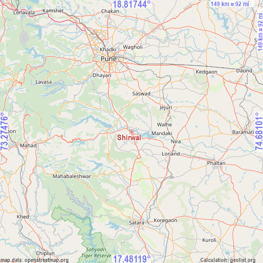
Shirwal GPS coordinates[2]
18° 9' 2.124" North, 73° 58' 40.368" East
| Map corner | latitude | longitude |
|---|---|---|
| Upper-left | 18.81744°, | 73.27476° |
| Center: | 18.15059°, | 73.97788° |
| Lower-right: | 17.48119°, | 74.68101° |
| Map W x H: | 148.6×148.6 km | = 92.3×92.3mi |
| max Lat: | 34.9274° ⇑71.4% North |
| Shirwal: | 18.15059° |
| min Lat: | ⇓28.6% South 8.09008° |
| min Long | Shirwal | max Long |
| 68.82655° | 73.97788° | 96.81° |
| W 10.3%⇐ | ⇒89.7% E |
Elevation
Elevation of Shirwal is 594 m = 1949 ft, and this is 298.4 m = 979 ft above average elevation for this country.
| Max E: |
3681 m = 12077 ft | 11.8% |
| Shirwal | 594 m 1949 ft | |
| Avg. | 295.6 m = 970 ft | |
Min E: |
1 m = 3 ft | 88.2% |
See also: India elevation on elevation.city.
Geographical zone
Shirwal is located in North Torrid zone (between Equator and Tropic of Cancer). Distance of this Northern Tropic circle is 587.8 km =365.2 mi to North.| Distance of | km | miles | from Shirwal |
|---|---|---|---|
| North Pole | 7988.9 | 4964.1 | to North |
| Arctic Circle | 5383 | 3344.8 | to North |
| Tropic Cancer | 587.8 | 365.2 | to North |
| Equator | 2018.2 | 1254.1 | to South |


Nearby cities:
15 places around Shirwal: (largest is in red/bold)
• Bhor
14.2 km =8.8 mi,  269°
269°
• Jejūri
23.8 km =14.8 mi,  53°
53°
• Khadki
47.8 km =29.7 mi,  343°
343°
• Kharakvasla
38.6 km =24 mi,  326°
326°
• Khed
25 km =15.5 mi, 326°
• Koregaon
55.7 km =34.6 mi,  8°
8°
• Lohogaon
50.2 km =31.2 mi,  353°
353°
• Phaltan
51.1 km =31.8 mi,  110°
110°
• Pimpri
55.5 km =34.5 mi, 341°
• Pune
43 km =26.7 mi, 342°
• Pānchgani
31.3 km =19.4 mi,  216°
216°
• Satara
51.7 km =32.1 mi,  178°
178°
• Shivaji Nagar
44.2 km =27.5 mi, 342°
• Sāsvad
22.2 km =13.8 mi, 14°
• Wai
23.9 km =14.9 mi,  202°
202°
Sources, notices
• [Note1] Compared only with cities in India existing in our database
• [Src1] Map data: © OpenStreetMap contributors (CC-BY-SA)
• [Src2] Other city data from geonames.org with taken over terms of usage.
• [Src3] Geographical zone / Annual Mean Temperature by Robert A. Rohde @ Wikipedia
