Sahāranpur geodata
Sahāranpur (Uttar Pradesh) is a populated place; located in India in Asia/Kolkata (GMT+5.5) time zone. With population of 484,873 people, there are 92 cities with bigger population in this country. Compared to other cities in India, 92.7% of cities are located further ↓South; 56.7% of cities are located further →East and 64.2% of cities have lower elevation than Sahāranpur. Note1


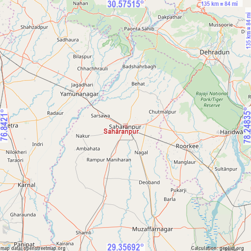
Sahāranpur GPS coordinates[2]
29° 58' 4.44" North, 77° 32' 42.792" East
| Map corner | latitude | longitude |
|---|---|---|
| Upper-left | 30.57515°, | 76.8421° |
| Center: | 29.9679°, | 77.54522° |
| Lower-right: | 29.35692°, | 78.24835° |
| Map W x H: | 135.5×135.5 km | = 84.2×84.2mi |
| max Lat: | 34.9274° ⇑7.3% North |
| Sahāranpur: | 29.9679° |
| min Lat: | ⇓92.7% South 8.09008° |
| min Long | Sahāranpur | max Long |
| 68.82655° | 77.54522° | 96.81° |
| W 43.3%⇐ | ⇒56.7% E |
Elevation
Elevation of Sahāranpur is 280 m = 919 ft, and this is 15.6 m = 51 ft below average elevation for this country.
| Max E: |
3681 m = 12077 ft | 35.8% |
| Avg. | 295.6 m = 970 ft | |
| Sahāranpur | 280 m = 919 ft | |
Min E: |
1 m = 3 ft | 64.2% |
See also: Sahāranpur elevation on elevation.city.
Geographical zone
Sahāranpur is located in North temperate zone (between Tropic of Cancer and the Arctic Circle). Distance of this Northern Tropic circle is 726.2 km =451.2 mi to South.| Distance of | km | miles | from Sahāranpur |
|---|---|---|---|
| North Pole | 6674.9 | 4147.6 | to North |
| Arctic Circle | 4069.1 | 2528.4 | to North |
| Tropic Cancer | 726.2 | 451.2 | to South |
| Equator | 3332.1 | 2070.5 | to South |


Nearby cities:
15 places around Sahāranpur: (largest is in red/bold)
• Ambahta
23.6 km =14.7 mi,  238°
238°
• Behat
23.6 km =14.7 mi,  16°
16°
• Būriya
27.9 km =17.3 mi,  319°
319°
• Chhachhrauli
35.6 km =22.1 mi,  329°
329°
• Chhutmalpur
21.3 km =13.2 mi,  70°
70°
• Deoband
33 km =20.5 mi,  156°
156°
• Gangoh
34.3 km =21.3 mi,  232°
232°
• Jagādhri
32.1 km =19.9 mi,  313°
313°
• Manglaur
37.7 km =23.4 mi,  121°
121°
• Nakūr
23.8 km =14.8 mi,  256°
256°
• Nanauta
31 km =19.3 mi,  203°
203°
• Radaur
38.5 km =23.9 mi,  279°
279°
• Roorkee
35.2 km =21.9 mi,  108°
108°
• Rāmpur
20.1 km =12.5 mi,  206°
206°
• Yamunānagar
30.8 km =19.1 mi, 305°
Sources, notices
• [Note1] Compared only with cities in India existing in our database
• [Src1] Map data: © OpenStreetMap contributors (CC-BY-SA)
• [Src2] Other city data from geonames.org with taken over terms of usage.
• [Src3] Geographical zone / Annual Mean Temperature by Robert A. Rohde @ Wikipedia
