Yamunānagar geodata
Yamunānagar (Haryana) is a populated place; located in India in Asia/Kolkata (GMT+5.5) time zone. With population of 208,931 people, there are 201 cities with bigger population in this country. Compared to other cities in India, 93.1% of cities are located further ↓South; 60.1% of cities are located further →East and 63.9% of cities have lower elevation than Yamunānagar. Note1


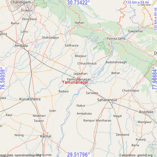
Yamunānagar GPS coordinates[2]
30° 7' 40.656" North, 77° 17' 1.356" East
| Map corner | latitude | longitude |
|---|---|---|
| Upper-left | 30.73422°, | 76.58059° |
| Center: | 30.12796°, | 77.28371° |
| Lower-right: | 29.51796°, | 77.98684° |
| Map W x H: | 135.2×135.2 km | = 84×84mi |
| max Lat: | 34.9274° ⇑6.9% North |
| Yamunānagar: | 30.12796° |
| min Lat: | ⇓93.1% South 8.09008° |
| min Long | Yamunānagar | max Long |
| 68.82655° | 77.28371° | 96.81° |
| W 39.9%⇐ | ⇒60.1% E |
Elevation
Elevation of Yamunānagar is 278 m = 912 ft, and this is 17.6 m = 58 ft below average elevation for this country.
| Max E: |
3681 m = 12077 ft | 36.1% |
| Avg. | 295.6 m = 970 ft | |
| Yamunānagar | 278 m = 912 ft | |
Min E: |
1 m = 3 ft | 63.9% |
See also: Yamunānagar elevation on elevation.city.
Geographical zone
Yamunānagar is located in North temperate zone (between Tropic of Cancer and the Arctic Circle). Distance of this Northern Tropic circle is 744 km =462.3 mi to South.| Distance of | km | miles | from Yamunānagar |
|---|---|---|---|
| North Pole | 6657.1 | 4136.5 | to North |
| Arctic Circle | 4051.3 | 2517.4 | to North |
| Tropic Cancer | 744 | 462.3 | to South |
| Equator | 3349.9 | 2081.5 | to South |


Nearby cities:
15 places around Yamunānagar: (largest is in red/bold)
• Ambahta
30.5 km =19 mi,  170°
170°
• Behat
32.1 km =19.9 mi,  81°
81°
• Bilāspur
19.7 km =12.2 mi,  5°
5°
• Būriya
8 km =5 mi,  64°
64°
• Chhachhrauli
14.9 km =9.3 mi,  29°
29°
• Gangoh
38.7 km =24 mi,  182°
182°
• Indri
35 km =21.7 mi,  218°
218°
• Jagādhri
4.8 km =3 mi,  23°
23°
• Lādwa
27.4 km =17 mi,  236°
236°
• Mustafābād
15.4 km =9.6 mi,  302°
302°
• Nakūr
23.2 km =14.4 mi, 175°
• Radaur
16.9 km =10.5 mi,  228°
228°
• Rāmpur
39.3 km =24.4 mi,  155°
155°
• Sahāranpur
30.8 km =19.1 mi,  125°
125°
• Shāhābād
40 km =24.9 mi,  276°
276°
Sources, notices
• [Note1] Compared only with cities in India existing in our database
• [Src1] Map data: © OpenStreetMap contributors (CC-BY-SA)
• [Src2] Other city data from geonames.org with taken over terms of usage.
• [Src3] Geographical zone / Annual Mean Temperature by Robert A. Rohde @ Wikipedia
