Mughal Sarāi geodata
Mughal Sarāi (Uttar Pradesh) is a populated place; located in India in Asia/Kolkata (GMT+5.5) time zone. With population of 98,043 people, there are 450 cities with bigger population in this country. Compared to other cities in India, 65% of cities are located further ↓South; 79.7% of cities are located further ←West and 71.8% of cities have higher elevation than Mughal Sarāi. Note1


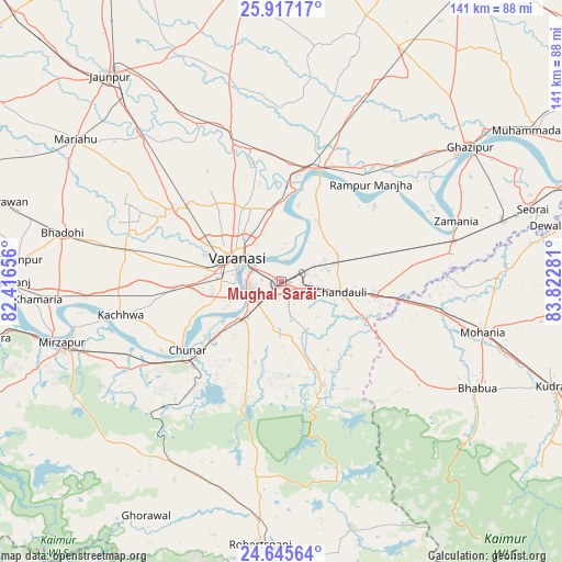
Mughal Sarāi GPS coordinates[2]
25° 16' 59.052" North, 83° 7' 10.848" East
| Map corner | latitude | longitude |
|---|---|---|
| Upper-left | 25.91717°, | 82.41656° |
| Center: | 25.28307°, | 83.11968° |
| Lower-right: | 24.64564°, | 83.82281° |
| Map W x H: | 141.4×141.4 km | = 87.9×87.9mi |
| max Lat: | 34.9274° ⇑35% North |
| Mughal Sarāi: | 25.28307° |
| min Lat: | ⇓65% South 8.09008° |
| min Long | Mughal Sarāi | max Long |
| 68.82655° | 83.11968° | 96.81° |
| W 79.7%⇐ | ⇒20.3% E |
Elevation
Elevation of Mughal Sarāi is 85 m = 279 ft, and this is 210.6 m = 691 ft below average elevation for this country.
| Max E: |
3681 m = 12077 ft | 71.8% |
| Avg. | 295.6 m = 970 ft | |
| Mughal Sarāi | 85 m = 279 ft | |
Min E: |
1 m = 3 ft | 28.2% |
See also: Mughal Sarāi elevation on elevation.city.
Geographical zone
Mughal Sarāi is located in North temperate zone (between Tropic of Cancer and the Arctic Circle). Distance of this Northern Tropic circle is 205.3 km =127.6 mi to South.| Distance of | km | miles | from Mughal Sarāi |
|---|---|---|---|
| North Pole | 7195.8 | 4471.3 | to North |
| Arctic Circle | 4590 | 2852.1 | to North |
| Tropic Cancer | 205.3 | 127.6 | to South |
| Equator | 2811.2 | 1746.8 | to South |


Nearby cities:
15 places around Mughal Sarāi: (largest is in red/bold)
• Ahraura
31 km =19.3 mi,  196°
196°
• Barāgaon
34.5 km =21.4 mi,  298°
298°
• Bhabhua
56 km =34.8 mi,  118°
118°
• Bhadohi
56.6 km =35.2 mi,  282°
282°
• Chakia
28 km =17.4 mi,  158°
158°
• Chandauli
15.2 km =9.4 mi,  100°
100°
• Chunār
29.5 km =18.3 mi,  234°
234°
• Ghazīpur
57.4 km =35.7 mi,  54°
54°
• Kachhwa
41.6 km =25.8 mi,  258°
258°
• Kirākat
44.4 km =27.6 mi,  332°
332°
• Rāmnagar
9.2 km =5.7 mi, 260°
• Saidpur
30.2 km =18.8 mi,  20°
20°
• Sādāt
46.9 km =29.1 mi, 23°
• Varanasi
11.6 km =7.2 mi,  288°
288°
• Zamānia
46.6 km =29 mi,  70°
70°
Sources, notices
• [Note1] Compared only with cities in India existing in our database
• [Src1] Map data: © OpenStreetMap contributors (CC-BY-SA)
• [Src2] Other city data from geonames.org with taken over terms of usage.
• [Src3] Geographical zone / Annual Mean Temperature by Robert A. Rohde @ Wikipedia
