Zamānia geodata
Zamānia (Uttar Pradesh) is a populated place; located in India in Asia/Kolkata (GMT+5.5) time zone. With population of 32,008 people, there are 1356 cities with bigger population in this country. Compared to other cities in India, 66.2% of cities are located further ↓South; 80.8% of cities are located further ←West and 74.2% of cities have higher elevation than Zamānia. Note1


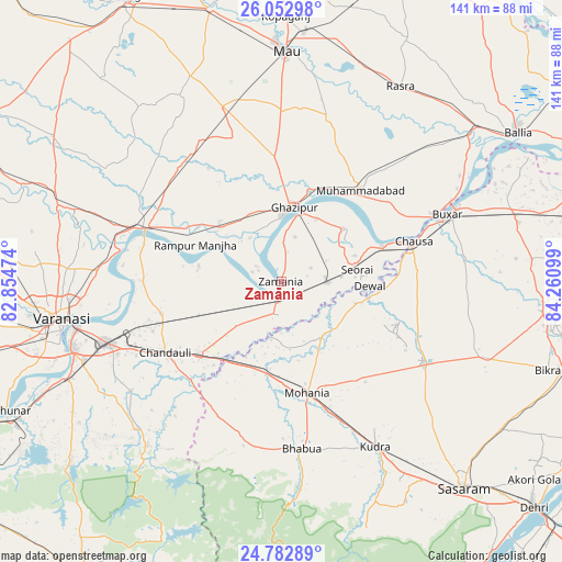
Zamānia GPS coordinates[2]
25° 25' 10.596" North, 83° 33' 28.296" East
| Map corner | latitude | longitude |
|---|---|---|
| Upper-left | 26.05298°, | 82.85474° |
| Center: | 25.41961°, | 83.55786° |
| Lower-right: | 24.78289°, | 84.26099° |
| Map W x H: | 141.2×141.2 km | = 87.7×87.7mi |
| max Lat: | 34.9274° ⇑33.8% North |
| Zamānia: | 25.41961° |
| min Lat: | ⇓66.2% South 8.09008° |
| min Long | Zamānia | max Long |
| 68.82655° | 83.55786° | 96.81° |
| W 80.8%⇐ | ⇒19.2% E |
Elevation
Elevation of Zamānia is 72 m = 236 ft, and this is 223.6 m = 734 ft below average elevation for this country.
| Max E: |
3681 m = 12077 ft | 74.2% |
| Avg. | 295.6 m = 970 ft | |
| Zamānia | 72 m = 236 ft | |
Min E: |
1 m = 3 ft | 25.8% |
See also: India elevation on elevation.city.
Geographical zone
Zamānia is located in North temperate zone (between Tropic of Cancer and the Arctic Circle). Distance of this Northern Tropic circle is 220.5 km =137 mi to South.| Distance of | km | miles | from Zamānia |
|---|---|---|---|
| North Pole | 7180.7 | 4461.9 | to North |
| Arctic Circle | 4574.8 | 2842.6 | to North |
| Tropic Cancer | 220.5 | 137 | to South |
| Equator | 2826.4 | 1756.2 | to South |


Nearby cities:
15 places around Zamānia: (largest is in red/bold)
• Bhabhua
42.4 km =26.3 mi,  173°
173°
• Buxar
45.8 km =28.5 mi,  67°
67°
• Chakia
53.3 km =33.1 mi,  219°
219°
• Chandauli
34.2 km =21.3 mi,  238°
238°
• Dumraon
61.4 km =38.2 mi,  76°
76°
• Ghazīpur
18.4 km =11.4 mi,  8°
8°
• Kopāganj
66.7 km =41.4 mi,  0°
0°
• Mau
58 km =36 mi, 0°
• Mughal Sarāi
46.6 km =29 mi,  250°
250°
• Muhammadābād
29.8 km =18.5 mi,  41°
41°
• Rasrā
57.1 km =35.5 mi,  31°
31°
• Rāmnagar
55.6 km =34.5 mi, 252°
• Saidpur
36 km =22.4 mi,  291°
291°
• Sādāt
37.9 km =23.5 mi,  317°
317°
• Varanasi
56.2 km =34.9 mi,  258°
258°
Sources, notices
• [Note1] Compared only with cities in India existing in our database
• [Src1] Map data: © OpenStreetMap contributors (CC-BY-SA)
• [Src2] Other city data from geonames.org with taken over terms of usage.
• [Src3] Geographical zone / Annual Mean Temperature by Robert A. Rohde @ Wikipedia
