Rusera geodata
Rusera (Bihar) is a populated place; located in India in Asia/Kolkata (GMT+5.5) time zone. With population of 28,781 people, there are 1503 cities with bigger population in this country. Compared to other cities in India, 68.8% of cities are located further ↓South; 87% of cities are located further ←West and 78.9% of cities have higher elevation than Rusera. Note1


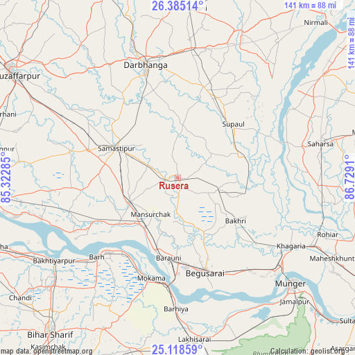
Rusera GPS coordinates[2]
25° 45' 12.78" North, 86° 1' 33.492" East
| Map corner | latitude | longitude |
|---|---|---|
| Upper-left | 26.38514°, | 85.32285° |
| Center: | 25.75355°, | 86.02597° |
| Lower-right: | 25.11859°, | 86.7291° |
| Map W x H: | 140.8×140.8 km | = 87.5×87.5mi |
| max Lat: | 34.9274° ⇑31.2% North |
| Rusera: | 25.75355° |
| min Lat: | ⇓68.8% South 8.09008° |
| min Long | Rusera | max Long |
| 68.82655° | 86.02597° | 96.81° |
| W 87%⇐ | ⇒13% E |
Elevation
Elevation of Rusera is 52 m = 171 ft, and this is 243.6 m = 799 ft below average elevation for this country.
| Max E: |
3681 m = 12077 ft | 78.9% |
| Avg. | 295.6 m = 970 ft | |
| Rusera | 52 m = 171 ft | |
Min E: |
1 m = 3 ft | 21.1% |
See also: India elevation on elevation.city.
Geographical zone
Rusera is located in North temperate zone (between Tropic of Cancer and the Arctic Circle). Distance of this Northern Tropic circle is 257.6 km =160.1 mi to South.| Distance of | km | miles | from Rusera |
|---|---|---|---|
| North Pole | 7143.5 | 4438.8 | to North |
| Arctic Circle | 4537.6 | 2819.5 | to North |
| Tropic Cancer | 257.6 | 160.1 | to South |
| Equator | 2863.5 | 1779.3 | to South |


Nearby cities:
15 places around Rusera: (largest is in red/bold)
• Bakhtiyārpur
59.2 km =36.8 mi,  236°
236°
• Bangaon
50.2 km =31.2 mi,  75°
75°
• Barhiya
51.8 km =32.2 mi,  180°
180°
• Begusarai
38.8 km =24.1 mi,  163°
163°
• Bhagirathpur
57.5 km =35.7 mi,  3°
3°
• Bārh
43.7 km =27.2 mi,  226°
226°
• Bāruni
31.5 km =19.6 mi,  190°
190°
• Dalsingh Sarai
21.2 km =13.2 mi, 243°
• Darbhanga
46.2 km =28.7 mi,  343°
343°
• Khagaria
52.3 km =32.5 mi,  122°
122°
• Mohiuddinnagar
40.9 km =25.4 mi, 240°
• Mokameh
41 km =25.5 mi, 194°
• Saharsa
58.6 km =36.4 mi, 76°
• Samāstipur
27.5 km =17.1 mi,  296°
296°
• Teghra
30.5 km =19 mi,  196°
196°
Sources, notices
• [Note1] Compared only with cities in India existing in our database
• [Src1] Map data: © OpenStreetMap contributors (CC-BY-SA)
• [Src2] Other city data from geonames.org with taken over terms of usage.
• [Src3] Geographical zone / Annual Mean Temperature by Robert A. Rohde @ Wikipedia
