Khagaria geodata
Khagaria (Bihar) is a populated place; located in India in Asia/Kolkata (GMT+5.5) time zone. With population of 49,982 people, there are 889 cities with bigger population in this country. Compared to other cities in India, 66.9% of cities are located further ↓South; 88.1% of cities are located further ←West and 80.2% of cities have higher elevation than Khagaria. Note1


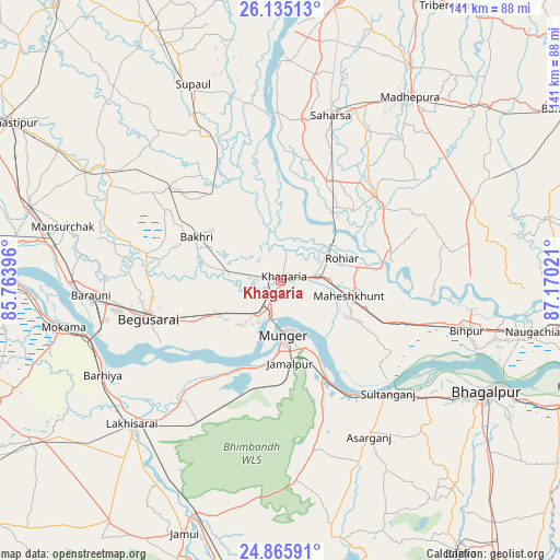
Khagaria GPS coordinates[2]
25° 30' 7.92" North, 86° 28' 1.488" East
| Map corner | latitude | longitude |
|---|---|---|
| Upper-left | 26.13513°, | 85.76396° |
| Center: | 25.5022°, | 86.46708° |
| Lower-right: | 24.86591°, | 87.17021° |
| Map W x H: | 141.1×141.1 km | = 87.7×87.7mi |
| max Lat: | 34.9274° ⇑33.1% North |
| Khagaria: | 25.5022° |
| min Lat: | ⇓66.9% South 8.09008° |
| min Long | Khagaria | max Long |
| 68.82655° | 86.46708° | 96.81° |
| W 88.1%⇐ | ⇒11.9% E |
Elevation
Elevation of Khagaria is 47 m = 154 ft, and this is 248.6 m = 816 ft below average elevation for this country.
| Max E: |
3681 m = 12077 ft | 80.2% |
| Avg. | 295.6 m = 970 ft | |
| Khagaria | 47 m = 154 ft | |
Min E: |
1 m = 3 ft | 19.8% |
See also: Khagaria elevation on elevation.city.
Geographical zone
Khagaria is located in North temperate zone (between Tropic of Cancer and the Arctic Circle). Distance of this Northern Tropic circle is 229.7 km =142.7 mi to South.| Distance of | km | miles | from Khagaria |
|---|---|---|---|
| North Pole | 7171.5 | 4456.2 | to North |
| Arctic Circle | 4565.6 | 2836.9 | to North |
| Tropic Cancer | 229.7 | 142.7 | to South |
| Equator | 2835.6 | 1762 | to South |


Nearby cities:
15 places around Khagaria: (largest is in red/bold)
• Asarganj
44.9 km =27.9 mi,  150°
150°
• Bangaon
40.8 km =25.4 mi,  6°
6°
• Barhiya
50.8 km =31.6 mi,  242°
242°
• Bariārpur
26.2 km =16.3 mi,  155°
155°
• Begusarai
34.7 km =21.6 mi,  254°
254°
• Bāruni
50.2 km =31.2 mi,  266°
266°
• Jamālpur
21.2 km =13.2 mi,  174°
174°
• Kharagpur
42.9 km =26.7 mi, 168°
• Luckeesarai
52.1 km =32.4 mi,  225°
225°
• Madhipura
56.9 km =35.4 mi,  34°
34°
• Mokameh
56 km =34.8 mi,  257°
257°
• Monghyr
14.2 km =8.8 mi,  176°
176°
• Rusera
52.3 km =32.5 mi,  302°
302°
• Saharsa
43.4 km =27 mi,  17°
17°
• Teghra
52.9 km =32.9 mi, 268°
Sources, notices
• [Note1] Compared only with cities in India existing in our database
• [Src1] Map data: © OpenStreetMap contributors (CC-BY-SA)
• [Src2] Other city data from geonames.org with taken over terms of usage.
• [Src3] Geographical zone / Annual Mean Temperature by Robert A. Rohde @ Wikipedia
