Saharsa geodata
Saharsa (Bihar) is a populated place; located in India in Asia/Kolkata (GMT+5.5) time zone. With population of 145,764 people, there are 301 cities with bigger population in this country. Compared to other cities in India, 69.5% of cities are located further ↓South; 88.5% of cities are located further ←West and 79.9% of cities have higher elevation than Saharsa. Note1


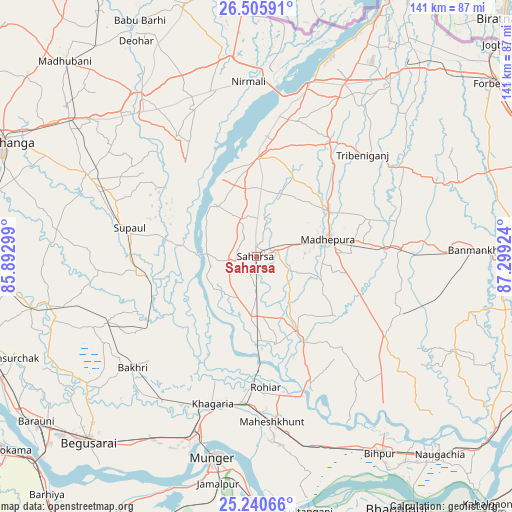
Saharsa GPS coordinates[2]
25° 52' 29.928" North, 86° 35' 45.996" East
| Map corner | latitude | longitude |
|---|---|---|
| Upper-left | 26.50591°, | 85.89299° |
| Center: | 25.87498°, | 86.59611° |
| Lower-right: | 25.24066°, | 87.29924° |
| Map W x H: | 140.7×140.7 km | = 87.4×87.4mi |
| max Lat: | 34.9274° ⇑30.5% North |
| Saharsa: | 25.87498° |
| min Lat: | ⇓69.5% South 8.09008° |
| min Long | Saharsa | max Long |
| 68.82655° | 86.59611° | 96.81° |
| W 88.5%⇐ | ⇒11.5% E |
Elevation
Elevation of Saharsa is 48 m = 157 ft, and this is 247.6 m = 812 ft below average elevation for this country.
| Max E: |
3681 m = 12077 ft | 79.9% |
| Avg. | 295.6 m = 970 ft | |
| Saharsa | 48 m = 157 ft | |
Min E: |
1 m = 3 ft | 20.1% |
See also: Saharsa elevation on elevation.city.
Geographical zone
Saharsa is located in North temperate zone (between Tropic of Cancer and the Arctic Circle). Distance of this Northern Tropic circle is 271.1 km =168.5 mi to South.| Distance of | km | miles | from Saharsa |
|---|---|---|---|
| North Pole | 7130 | 4430.4 | to North |
| Arctic Circle | 4524.1 | 2811.1 | to North |
| Tropic Cancer | 271.1 | 168.5 | to South |
| Equator | 2877 | 1787.7 | to South |


Nearby cities:
15 places around Saharsa: (largest is in red/bold)
• Bangaon
8.5 km =5.3 mi,  264°
264°
• Banmankhi
59.9 km =37.2 mi,  88°
88°
• Bariārpur
65.3 km =40.6 mi,  181°
181°
• Begusarai
68.7 km =42.7 mi,  222°
222°
• Bihārīganj
42.3 km =26.3 mi,  111°
111°
• Chhātāpur
56 km =34.8 mi,  46°
46°
• Jamālpur
63.5 km =39.5 mi,  189°
189°
• Jhanjhārpur
53.6 km =33.3 mi,  323°
323°
• Khagaria
43.4 km =27 mi,  197°
197°
• Madhipura
20.3 km =12.6 mi,  75°
75°
• Monghyr
57 km =35.4 mi, 192°
• Murlīganj
40.1 km =24.9 mi, 86°
• Nirmāli
48.8 km =30.3 mi,  358°
358°
• Rusera
58.6 km =36.4 mi, 256°
• Supaul
26.7 km =16.6 mi, 359°
Sources, notices
• [Note1] Compared only with cities in India existing in our database
• [Src1] Map data: © OpenStreetMap contributors (CC-BY-SA)
• [Src2] Other city data from geonames.org with taken over terms of usage.
• [Src3] Geographical zone / Annual Mean Temperature by Robert A. Rohde @ Wikipedia
