Darbhanga geodata
Darbhanga (Bihar) is a populated place; located in India in Asia/Kolkata (GMT+5.5) time zone. With population of 287,150 people, there are 154 cities with bigger population in this country. Compared to other cities in India, 71.5% of cities are located further ↓South; 86.7% of cities are located further ←West and 77.2% of cities have higher elevation than Darbhanga. Note1


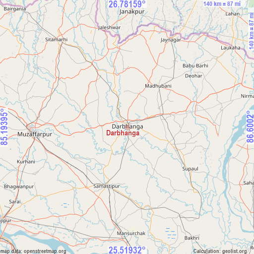
Darbhanga GPS coordinates[2]
26° 9' 7.776" North, 85° 53' 49.452" East
| Map corner | latitude | longitude |
|---|---|---|
| Upper-left | 26.78159°, | 85.19395° |
| Center: | 26.15216°, | 85.89707° |
| Lower-right: | 25.51932°, | 86.6002° |
| Map W x H: | 140.4×140.4 km | = 87.2×87.2mi |
| max Lat: | 34.9274° ⇑28.5% North |
| Darbhanga: | 26.15216° |
| min Lat: | ⇓71.5% South 8.09008° |
| min Long | Darbhanga | max Long |
| 68.82655° | 85.89707° | 96.81° |
| W 86.7%⇐ | ⇒13.3% E |
Elevation
Elevation of Darbhanga is 58 m = 190 ft, and this is 237.6 m = 780 ft below average elevation for this country.
| Max E: |
3681 m = 12077 ft | 77.2% |
| Avg. | 295.6 m = 970 ft | |
| Darbhanga | 58 m = 190 ft | |
Min E: |
1 m = 3 ft | 22.8% |
See also: Darbhanga elevation on elevation.city.
Geographical zone
Darbhanga is located in North temperate zone (between Tropic of Cancer and the Arctic Circle). Distance of this Northern Tropic circle is 301.9 km =187.6 mi to South.| Distance of | km | miles | from Darbhanga |
|---|---|---|---|
| North Pole | 7099.2 | 4411.2 | to North |
| Arctic Circle | 4493.3 | 2792 | to North |
| Tropic Cancer | 301.9 | 187.6 | to South |
| Equator | 2907.8 | 1806.8 | to South |


Nearby cities:
15 places around Darbhanga: (largest is in red/bold)
• Bangaon
69.1 km =42.9 mi,  117°
117°
• Belsand
59.1 km =36.7 mi,  303°
303°
• Bhagirathpur
21.1 km =13.1 mi,  51°
51°
• Dalsingh Sarai
54.2 km =33.7 mi,  186°
186°
• Dumra
59.5 km =37 mi,  320°
320°
• Jaynagar
54.3 km =33.7 mi,  26°
26°
• Jhanjhārpur
40.2 km =25 mi,  71°
71°
• Madhubani
28.4 km =17.6 mi,  37°
37°
• Mohiuddinnagar
68.2 km =42.4 mi,  199°
199°
• Muzaffarpur
50.7 km =31.5 mi,  266°
266°
• Pupri
40.4 km =25.1 mi,  331°
331°
• Rusera
46.2 km =28.7 mi,  163°
163°
• Samāstipur
34.3 km =21.3 mi, 200°
• Supaul
69.8 km =43.4 mi,  93°
93°
• Sītāmarhi
63.6 km =39.5 mi, 320°
Sources, notices
• [Note1] Compared only with cities in India existing in our database
• [Src1] Map data: © OpenStreetMap contributors (CC-BY-SA)
• [Src2] Other city data from geonames.org with taken over terms of usage.
• [Src3] Geographical zone / Annual Mean Temperature by Robert A. Rohde @ Wikipedia
