Bhādra geodata
Bhādra (Rajasthan) is a populated place; located in India in Asia/Kolkata (GMT+5.5) time zone. With population of 37,629 people, there are 1173 cities with bigger population in this country. Compared to other cities in India, 89.3% of cities are located further ↓South; 81.2% of cities are located further →East and 50.2% of cities have higher elevation than Bhādra. Note1


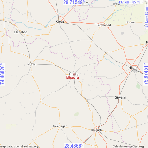
Bhādra GPS coordinates[2]
29° 6' 10.728" North, 75° 10' 16.968" East
| Map corner | latitude | longitude |
|---|---|---|
| Upper-left | 29.71549°, | 74.46826° |
| Center: | 29.10298°, | 75.17138° |
| Lower-right: | 28.4868°, | 75.87451° |
| Map W x H: | 136.6×136.6 km | = 84.9×84.9mi |
| max Lat: | 34.9274° ⇑10.7% North |
| Bhādra: | 29.10298° |
| min Lat: | ⇓89.3% South 8.09008° |
| min Long | Bhādra | max Long |
| 68.82655° | 75.17138° | 96.81° |
| W 18.8%⇐ | ⇒81.2% E |
Elevation
Elevation of Bhādra is 200 m = 656 ft, and this is 95.6 m = 314 ft below average elevation for this country.
| Max E: |
3681 m = 12077 ft | 50.2% |
| Avg. | 295.6 m = 970 ft | |
| Bhādra | 200 m = 656 ft | |
Min E: |
1 m = 3 ft | 49.8% |
See also: India elevation on elevation.city.
Geographical zone
Bhādra is located in North temperate zone (between Tropic of Cancer and the Arctic Circle). Distance of this Northern Tropic circle is 630 km =391.5 mi to South.| Distance of | km | miles | from Bhādra |
|---|---|---|---|
| North Pole | 6771.1 | 4207.4 | to North |
| Arctic Circle | 4165.2 | 2588.1 | to North |
| Tropic Cancer | 630 | 391.5 | to South |
| Equator | 3235.9 | 2010.7 | to South |


Nearby cities:
15 places around Bhādra: (largest is in red/bold)
• Ellenabad
62.9 km =39.1 mi,  308°
308°
• Fatehābād
53.5 km =33.2 mi,  31°
31°
• Gorakhpur
61.9 km =38.5 mi,  51°
51°
• Hisar
53.9 km =33.5 mi,  83°
83°
• Hānsi
76.9 km =47.8 mi,  90°
90°
• Mandholi Kalān
66.4 km =41.3 mi,  131°
131°
• Nohar
39.9 km =24.8 mi,  282°
282°
• Ratia
76.2 km =47.3 mi, 31°
• Rājgarh
55.4 km =34.4 mi,  157°
157°
• Rānia
57 km =35.4 mi,  325°
325°
• Rāwatsār
76.8 km =47.7 mi, 283°
• Sardulgarh
65.8 km =40.9 mi,  5°
5°
• Sirsa
50 km =31.1 mi,  343°
343°
• Toshām
77 km =47.8 mi,  109°
109°
• Tārānagar
50.2 km =31.2 mi,  195°
195°
Sources, notices
• [Note1] Compared only with cities in India existing in our database
• [Src1] Map data: © OpenStreetMap contributors (CC-BY-SA)
• [Src2] Other city data from geonames.org with taken over terms of usage.
• [Src3] Geographical zone / Annual Mean Temperature by Robert A. Rohde @ Wikipedia
