Sūratgarh geodata
Sūratgarh (Rajasthan) is a populated place; located in India in Asia/Kolkata (GMT+5.5) time zone. With population of 63,153 people, there are 698 cities with bigger population in this country. Compared to other cities in India, 90.3% of cities are located further ↓South; 90.3% of cities are located further →East and 55.6% of cities have higher elevation than Sūratgarh. Note1


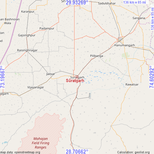
Sūratgarh GPS coordinates[2]
29° 19' 17.4" North, 73° 53' 59.244" East
| Map corner | latitude | longitude |
|---|---|---|
| Upper-left | 29.93269°, | 73.19667° |
| Center: | 29.3215°, | 73.89979° |
| Lower-right: | 28.70662°, | 74.60292° |
| Map W x H: | 136.3×136.3 km | = 84.7×84.7mi |
| max Lat: | 34.9274° ⇑9.7% North |
| Sūratgarh: | 29.3215° |
| min Lat: | ⇓90.3% South 8.09008° |
| min Long | Sūratgarh | max Long |
| 68.82655° | 73.89979° | 96.81° |
| W 9.7%⇐ | ⇒90.3% E |
Elevation
Elevation of Sūratgarh is 172 m = 564 ft, and this is 123.6 m = 406 ft below average elevation for this country.
| Max E: |
3681 m = 12077 ft | 55.6% |
| Avg. | 295.6 m = 970 ft | |
| Sūratgarh | 172 m = 564 ft | |
Min E: |
1 m = 3 ft | 44.4% |
See also: Sūratgarh elevation on elevation.city.
Geographical zone
Sūratgarh is located in North temperate zone (between Tropic of Cancer and the Arctic Circle). Distance of this Northern Tropic circle is 654.3 km =406.6 mi to South.| Distance of | km | miles | from Sūratgarh |
|---|---|---|---|
| North Pole | 6746.8 | 4192.3 | to North |
| Arctic Circle | 4140.9 | 2573 | to North |
| Tropic Cancer | 654.3 | 406.6 | to South |
| Equator | 3260.2 | 2025.8 | to South |


Nearby cities:
15 places around Sūratgarh: (largest is in red/bold)
• Abohar
95.9 km =59.6 mi,  17°
17°
• Anūpgarh
68.6 km =42.6 mi,  257°
257°
• Dabwāli
106.9 km =66.4 mi,  49°
49°
• Ellenabad
75.2 km =46.7 mi,  78°
78°
• Gangānagar
66.6 km =41.4 mi,  357°
357°
• Hanumāngarh
50.7 km =31.5 mi,  55°
55°
• Karanpur
72 km =44.7 mi,  323°
323°
• Nohar
85.9 km =53.4 mi,  100°
100°
• Padampur
50.6 km =31.4 mi,  328°
328°
• Pilibangan
24.1 km =15 mi, 53°
• Rāisinghnagar
49.7 km =30.9 mi,  298°
298°
• Rānia
93.5 km =58.1 mi, 76°
• Rāwatsār
49.2 km =30.6 mi, 97°
• Sangariā
76.3 km =47.4 mi, 45°
• Sirsa
111.9 km =69.5 mi, 77°
Sources, notices
• [Note1] Compared only with cities in India existing in our database
• [Src1] Map data: © OpenStreetMap contributors (CC-BY-SA)
• [Src2] Other city data from geonames.org with taken over terms of usage.
• [Src3] Geographical zone / Annual Mean Temperature by Robert A. Rohde @ Wikipedia
