Rasūlābād geodata
Rasūlābād (Uttar Pradesh) is a populated place; located in India in Asia/Kolkata (GMT+5.5) time zone. With population of 7,800 people, there are 3138 cities with bigger population in this country. Compared to other cities in India, 76.4% of cities are located further ↓South; 70.9% of cities are located further ←West and 63.2% of cities have higher elevation than Rasūlābād. Note1


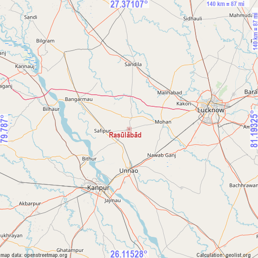
Rasūlābād GPS coordinates[2]
26° 44' 41.676" North, 80° 29' 24.432" East
| Map corner | latitude | longitude |
|---|---|---|
| Upper-left | 27.37107°, | 79.787° |
| Center: | 26.74491°, | 80.49012° |
| Lower-right: | 26.11528°, | 81.19325° |
| Map W x H: | 139.6×139.6 km | = 86.7×86.7mi |
| max Lat: | 34.9274° ⇑23.6% North |
| Rasūlābād: | 26.74491° |
| min Lat: | ⇓76.4% South 8.09008° |
| min Long | Rasūlābād | max Long |
| 68.82655° | 80.49012° | 96.81° |
| W 70.9%⇐ | ⇒29.1% E |
Elevation
Elevation of Rasūlābād is 131 m = 430 ft, and this is 164.6 m = 540 ft below average elevation for this country.
| Max E: |
3681 m = 12077 ft | 63.2% |
| Avg. | 295.6 m = 970 ft | |
| Rasūlābād | 131 m = 430 ft | |
Min E: |
1 m = 3 ft | 36.8% |
See also: India elevation on elevation.city.
Geographical zone
Rasūlābād is located in North temperate zone (between Tropic of Cancer and the Arctic Circle). Distance of this Northern Tropic circle is 367.8 km =228.5 mi to South.| Distance of | km | miles | from Rasūlābād |
|---|---|---|---|
| North Pole | 7033.3 | 4370.3 | to North |
| Arctic Circle | 4427.4 | 2751.1 | to North |
| Tropic Cancer | 367.8 | 228.5 | to South |
| Equator | 2973.8 | 1847.8 | to South |


Nearby cities:
15 places around Rasūlābād: (largest is in red/bold)
• Aurās
18.9 km =11.7 mi,  5°
5°
• Bithūr
26.7 km =16.6 mi,  234°
234°
• Bāngarmau
32.1 km =19.9 mi,  300°
300°
• Fatehpur Chaurāsi
22.8 km =14.2 mi,  282°
282°
• Ganj Murādābād
38.5 km =23.9 mi,  307°
307°
• Jagdīshpur
5.5 km =3.4 mi,  84°
84°
• Kanpur
34.1 km =21.2 mi,  204°
204°
• Kākori
32.4 km =20.1 mi,  64°
64°
• Malīhābād
29.5 km =18.3 mi,  47°
47°
• Mohān
18.8 km =11.7 mi, 77°
• Nawābganj
32.9 km =20.4 mi,  213°
213°
• Safīpur
14.6 km =9.1 mi,  266°
266°
• Sandīla
36.2 km =22.5 mi,  3°
3°
• Ugu
17.8 km =11.1 mi,  288°
288°
• Unnāo
22 km =13.7 mi,  180°
180°
Sources, notices
• [Note1] Compared only with cities in India existing in our database
• [Src1] Map data: © OpenStreetMap contributors (CC-BY-SA)
• [Src2] Other city data from geonames.org with taken over terms of usage.
• [Src3] Geographical zone / Annual Mean Temperature by Robert A. Rohde @ Wikipedia
