Sandīla geodata
Sandīla (Uttar Pradesh) is a populated place; located in India in Asia/Kolkata (GMT+5.5) time zone. With population of 53,182 people, there are 838 cities with bigger population in this country. Compared to other cities in India, 79% of cities are located further ↓South; 71% of cities are located further ←West and 61.8% of cities have higher elevation than Sandīla. Note1


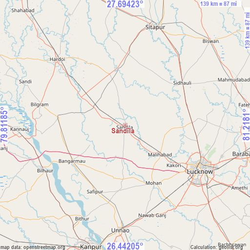
Sandīla GPS coordinates[2]
27° 4' 11.604" North, 80° 30' 53.892" East
| Map corner | latitude | longitude |
|---|---|---|
| Upper-left | 27.69423°, | 79.81185° |
| Center: | 27.06989°, | 80.51497° |
| Lower-right: | 26.44205°, | 81.2181° |
| Map W x H: | 139.2×139.2 km | = 86.5×86.5mi |
| max Lat: | 34.9274° ⇑21% North |
| Sandīla: | 27.06989° |
| min Lat: | ⇓79% South 8.09008° |
| min Long | Sandīla | max Long |
| 68.82655° | 80.51497° | 96.81° |
| W 71%⇐ | ⇒29% E |
Elevation
Elevation of Sandīla is 139 m = 456 ft, and this is 156.6 m = 514 ft below average elevation for this country.
| Max E: |
3681 m = 12077 ft | 61.8% |
| Avg. | 295.6 m = 970 ft | |
| Sandīla | 139 m = 456 ft | |
Min E: |
1 m = 3 ft | 38.2% |
See also: Sandīla elevation on elevation.city.
Geographical zone
Sandīla is located in North temperate zone (between Tropic of Cancer and the Arctic Circle). Distance of this Northern Tropic circle is 404 km =251 mi to South.| Distance of | km | miles | from Sandīla |
|---|---|---|---|
| North Pole | 6997.2 | 4347.9 | to North |
| Arctic Circle | 4391.3 | 2728.6 | to North |
| Tropic Cancer | 404 | 251 | to South |
| Equator | 3009.9 | 1870.3 | to South |


Nearby cities:
15 places around Sandīla: (largest is in red/bold)
• Aurās
17.3 km =10.7 mi,  182°
182°
• Benīganj
25.8 km =16 mi,  344°
344°
• Bāngarmau
36 km =22.4 mi,  236°
236°
• Fatehpur Chaurāsi
39.8 km =24.7 mi,  218°
218°
• Ganj Murādābād
35.1 km =21.8 mi,  249°
249°
• Itaunja
37.8 km =23.5 mi,  87°
87°
• Jagdīshpur
35.7 km =22.2 mi, 175°
• Kākori
35 km =21.7 mi,  129°
129°
• Malīhābād
25.4 km =15.8 mi, 130°
• Misrikh
40.2 km =25 mi,  2°
2°
• Mohān
35.9 km =22.3 mi,  153°
153°
• Mādhoganj
37.4 km =23.2 mi,  278°
278°
• Rasūlābād
36.2 km =22.5 mi, 183°
• Sidhaulī
39.4 km =24.5 mi,  53°
53°
• Ugu
35.9 km =22.3 mi,  212°
212°
Sources, notices
• [Note1] Compared only with cities in India existing in our database
• [Src1] Map data: © OpenStreetMap contributors (CC-BY-SA)
• [Src2] Other city data from geonames.org with taken over terms of usage.
• [Src3] Geographical zone / Annual Mean Temperature by Robert A. Rohde @ Wikipedia
