Mohān geodata
Mohān (Uttar Pradesh) is a populated place; located in India in Asia/Kolkata (GMT+5.5) time zone. With population of 14,709 people, there are 2493 cities with bigger population in this country. Compared to other cities in India, 76.7% of cities are located further ↓South; 71.6% of cities are located further ←West and 64.2% of cities have higher elevation than Mohān. Note1


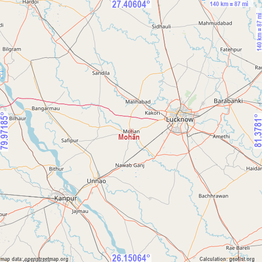
Mohān GPS coordinates[2]
26° 46' 48.288" North, 80° 40' 29.892" East
| Map corner | latitude | longitude |
|---|---|---|
| Upper-left | 27.40604°, | 79.97185° |
| Center: | 26.78008°, | 80.67497° |
| Lower-right: | 26.15064°, | 81.3781° |
| Map W x H: | 139.6×139.6 km | = 86.7×86.7mi |
| max Lat: | 34.9274° ⇑23.3% North |
| Mohān: | 26.78008° |
| min Lat: | ⇓76.7% South 8.09008° |
| min Long | Mohān | max Long |
| 68.82655° | 80.67497° | 96.81° |
| W 71.6%⇐ | ⇒28.4% E |
Elevation
Elevation of Mohān is 126 m = 413 ft, and this is 169.6 m = 556 ft below average elevation for this country.
| Max E: |
3681 m = 12077 ft | 64.2% |
| Avg. | 295.6 m = 970 ft | |
| Mohān | 126 m = 413 ft | |
Min E: |
1 m = 3 ft | 35.8% |
See also: India elevation on elevation.city.
Geographical zone
Mohān is located in North temperate zone (between Tropic of Cancer and the Arctic Circle). Distance of this Northern Tropic circle is 371.7 km =231 mi to South.| Distance of | km | miles | from Mohān |
|---|---|---|---|
| North Pole | 7029.4 | 4367.9 | to North |
| Arctic Circle | 4423.5 | 2748.6 | to North |
| Tropic Cancer | 371.7 | 231 | to South |
| Equator | 2977.7 | 1850.3 | to South |


Nearby cities:
15 places around Mohān: (largest is in red/bold)
• Aurās
22.3 km =13.9 mi,  311°
311°
• Fatehpur Chaurāsi
40.7 km =25.3 mi,  271°
271°
• Goshāīnganj
43 km =26.7 mi,  91°
91°
• Itaunja
40.3 km =25 mi,  33°
33°
• Jagdīshpur
13.3 km =8.3 mi,  255°
255°
• Kākori
14.7 km =9.1 mi,  48°
48°
• Lucknow
25.5 km =15.8 mi,  75°
75°
• Malīhābād
16.2 km =10.1 mi,  12°
12°
• Maurānwān
44.1 km =27.4 mi,  152°
152°
• Purwā
37.2 km =23.1 mi,  164°
164°
• Rasūlābād
18.8 km =11.7 mi, 257°
• Safīpur
33.2 km =20.6 mi, 261°
• Sandīla
35.9 km =22.3 mi,  333°
333°
• Ugu
35.2 km =21.9 mi, 273°
• Unnāo
31.9 km =19.8 mi,  215°
215°
Sources, notices
• [Note1] Compared only with cities in India existing in our database
• [Src1] Map data: © OpenStreetMap contributors (CC-BY-SA)
• [Src2] Other city data from geonames.org with taken over terms of usage.
• [Src3] Geographical zone / Annual Mean Temperature by Robert A. Rohde @ Wikipedia
